Project Ootjoolik (1992)
© David C. Woodman 1993
[A shortened version of this article was published in 1993 as “Project Ootjoolik,” Sentinel, 29.2 (April-May): 28-29]
The spring of 1992 found me serving as Second Officer on the Oceanographic Research Vessel Endeavour. I had been out of the Navy for four years but still retained a reasonably close connection as the Endeavour was often tasked to serve as a platform for research conducted by the Defence Research Establishment Pacific (DREP). DREP was essentially a “boffin shop” where the best and brightest scientists and technologists were busy developing new sensors, computers, and weapons systems for the modern Navy. Some regular Naval Officers were stationed there as program coordinators to coordinate these “longhairs” and ensure that the Navy programs weren’t sidetracked by pure science. One of these was my old friend Lt(N) Bob Gwalchmai, affectionately known to all as “G.W.”
For the project at hand, the Navy wanted to test the penetrating power and resolution of a multispectral airborne sensor package developed locally by Borstad Associates. This involved placing markers on the seabed at different depths and flying over them with the sensors to determine the use parameters. The Endeavour needed to locate a few miles from the base and serve as a floating hotel and workshop for the scientists involved – a not particularly challenging or exciting task for the ship’s navigating officer, so I planned to do a lot of reading.
One can’t be antisocial, so G.W., Gary Borstad, and I would share a beer after dinner and discuss our hobbies (G.W., by the way, is a world-class blacksmith and woodcarver). Talk eventually and predictably turned to my quest for the Franklin wreck and whether we could use Gary’s equipment array (a Compact Airborne Spectrographic Imager (CASI)) to find a wreck in 100’ of water. Gary was sure that he could find a wreck if it were in slightly shallower water. He also had experience in using the equipment for surveys in the arctic. Unfortunately, even if we “piggybacked” on another arctic tasking, the price tag would be $20,000 to do the survey area I had planned.
The problem was that the search area was dauntingly large even with the geographical clues bequeathed us from Inuit testimony. Overall we had a 700 sq km area to cover, although I was pretty sure that the wreck would be found in the northern half of this area and was intending to search this area first. Even so, it was apparent that we would need a technological trick to narrow down the search. Since the native stories indicated that the wreck would be too deep for Gary’s gear, I wondered whether we could use the metal parts of the ship to locate it.
I knew from my reading that in 1965 geologists using a magnetometer on a sled had surveyed a small part of the area around O’Reilly Is. to investigate a magnetic anomaly. Hypothesized to be one of Franklin’s ships, it turned out to be a geological structure, “magnetite in serpentine.” Perhaps an airborne mag might be helpful to survey our large area. As an ex-submariner, I knew that long-range patrol craft used such an instrument in submarine hunting, and I fantasized out loud to G.W. about getting one to do “runs” over the Franklin site.
I didn’t expect to be taken too seriously – you can’t just charter a specialized military aircraft – but G.W. said it was an idea which might be worth pursuing and told me to come up to his office the next time I was back in the base. About a week later, I walked up to DREP, and G.W. introduced me to Mr. Brad Nelson, Head of the Magnetics Section. To my surprise, Brad didn’t laugh outright at my idea but asked me about the size of the engines and deck plating on the Franklin ships, the depth of water, and other parameters while he took careful notes. Always a cautious scientist, he said that he would run the information through his software models, telling us whether the ship would produce a significant signal on a military airborne mag – I was to come back in a week.
As it turned out, I had taken my problem to the one man currently working on enhanced processing techniques for Magnetic Anomaly Detection (MAD). As I sat in his office a week later, Brad explained that Franklin’s ships had enough iron in their bow plating and rudimentary (but heavy – fifteen-ton) steam engines to deflect the earth’s normal magnetic field. His calculations concluded that if survey lines could be accurately flown at 150m spacing, there was a good chance of detection.
Luckily, Brad had an ongoing series of experiments in the Arctic and often used a long-range patrol aircraft from the Maritime Proving and Evaluation Unit (MPEU) in his work. The same squadron, based on the other side of the continent in Greenwood, Nova Scotia, provided aircraft for the periodic NORPATs – Northern Sovereignty Patrols through the Arctic. Brad thought it might be possible to entice the powers at Air Command to loan us the use of one of these aircraft for a slight diversion and an hour or two of equipment testing on a historically-significant “target of opportunity.”
As with everything, luck and timing were crucial. I had maintained a tenuous link to the Navy by remaining a member of the Naval Reserves. In addition to my current working and social contacts among my contemporaries, my last posting had been at the Operations Center at Maritime Forces Pacific, and the Naval Chief of Staff, who had been my previous boss, was still there. G.W. and Brad helped me draft a proposal for him for the project and tutored me in how to include enough corollary military and scientific benefits for a high-definition survey in a “virgin” area to justify the hijacking of an expensive and irreplaceable piece of military air power. With the COS’s recommendation, this proposal went to the Pacific Admiral, then to Maritime Command Headquarters, then to Air Command Headquarters, and back down through their chain of command to the staff at MPEU for evaluation. Knowing the intricate chain of approvals required, I had very little hope that we could pull this off – but you have to try.
Four months after my proposal disappeared into the great silence of modern military bureaucracy, I got a phone call at work. The voice on the phone introduced himself as Major Howden from MPEU. The name didn’t ring any bells immediately, but the voice sounded vaguely familiar to me, and the pennies started to drop with his first question – was my nickname “Woody”? I admitted that, like almost everyone whose surnames begin in W-O-O-D, I had not managed to avoid that label all my life. Had I been an Officer Cadet in the 22nd Qualifying Unit in 1978? That did it, and I remembered the voice – “Hi Scotty, how are things?” I asked. As it turned out, my request had ended up on the desk of one of my best but long-lost friends from boot camp. Somewhere the gods were smiling on me. After a few quick clarifying questions, I was assured that the staff at the MPEU would recommend the magnetometer survey for the Franklin wreck. Scott assured me that it sounded like a “fun assignment” and that the aircrew would be thrilled to do something like this, but warned me, as I already knew, that this did not guarantee that higher command would approve the project.
Two months of staff work later, I received official approval for “PROJECT OOTJOOLIK.” I had few illusions that I would participate in the survey flights – Brad had more than enough information to do this alone. Brad and/or Scott had taken pity on me, and in due course, my joining instructions arrived – I was temporarily posted to the project from my Naval Reserve Unit. Early July found me struggling into my surprisingly-tight Navy uniform and boarding a Hercules transport aircraft en route to the arctic for the first time.
I was to meet Scott, Brad, and the team in Yellowknife. As I unpacked at the Explorer Hotel, I couldn’t help but feel disappointed with Yellowknife. I had been expecting a frontier town and found myself in a luxury hotel in a modern, clean, and friendly little city of about 20,000 – complete with paved streets, parking meters, and a Kentucky Fried Chicken outlet.
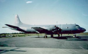
The next morning, July 9th, Brad and I met with Major Ron Sarich, Scott, and the three pilots who would be flying the Aurora patrol aircraft to discuss our plans. Brad had worked out a series of fifty-five lines, each fifteen miles long, which could be flown on an “advancing racetrack” pattern. These lines, flown at a very low altitude, would require unremitting and intense concentration by pilots and navigators, so intense that the three pilots would rotate after each line on the quick “end loops.” The hoped-for accuracy was to maintain the track within ten meters – almost unheard of precision in an aircraft doing over one hundred miles an hour. One of the pilots ruined my day by pointing out that from our survey altitude, it would take less than a second to impact the ice – and that judging altitude over water and ice was always “a bit of a problem,” even in the best of conditions.
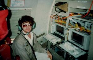
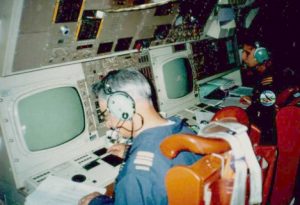
We were using a test aircraft, number 101, crammed full of electronics and control instrumentation. As I boarded the plane, young airmen and women were sitting at panels with hundreds of blinking lights and switches, busy doing pre-mission checks and quietly going through checklists. I was politely shown my position in the rear near an observer’s port across from the galley. Here I was out of the way and couldn’t hurt anything. For the first (but not the last) time in the search for the ships, I realized that I was the least important person involved.
Flying conditions were perfect during the two-hour transit northeast over the “Barren Lands.” The trees had disappeared within minutes of takeoff from Yellowknife, and out my window stretched unimaginable miles of empty tundra interlaced with innumerable lakes and rivers. As we approached the Arctic Ocean, I could make out the winding Back River below, known as the Great Fish River to Franklin’s men. Most historians believe this river was the chosen route home for the survivors of the two beleaguered ships. While flying above it at twenty-five thousand feet, munching on a box lunch, it was impossible to imagine the effort that would have been required for one hundred exhausted seamen to ascend that six-hundred-mile-long river. Back had described it as “running through an iron-ribbed country without a single tree . . . and broken into falls, cascades, and rapids, to the number of no less than eighty-three.”
Leaving the mainland behind, we turned eastward over Queen Maud Gulf and commenced photo reconnaissance runs at ten thousand feet. The existing maps and charts in this area warn that islands might be nonexistent or up to one mile from their reported positions. The resulting photomosaic might resolve these difficulties and contribute to a more accurate representation of this infrequently visited corner of the Arctic.
The possibility of improving local cartography was only one of the purported benefits I had used to entice the military into letting me “borrow” one of their aircraft for my selfish purposes. I also pointed out the likelihood that in the future, with the enormous increase in trans-polar intercontinental flights, it would be necessary to conduct a detailed surface or sub-surface search for a downed aircraft. The military had also absorbed the lessons learned after searching for the remains of the Soviet maritime-surveillance satellite Cosmos 954, which fell to earth northeast of Yellowknife on January 24th, 1978. As the flight progressed, I was told by the crew that other more direct benefits were the calibration of Brad’s gear, the practice in high-precision flying and the fun involved in doing something a little different from their typical “show the flag” arctic patrols.
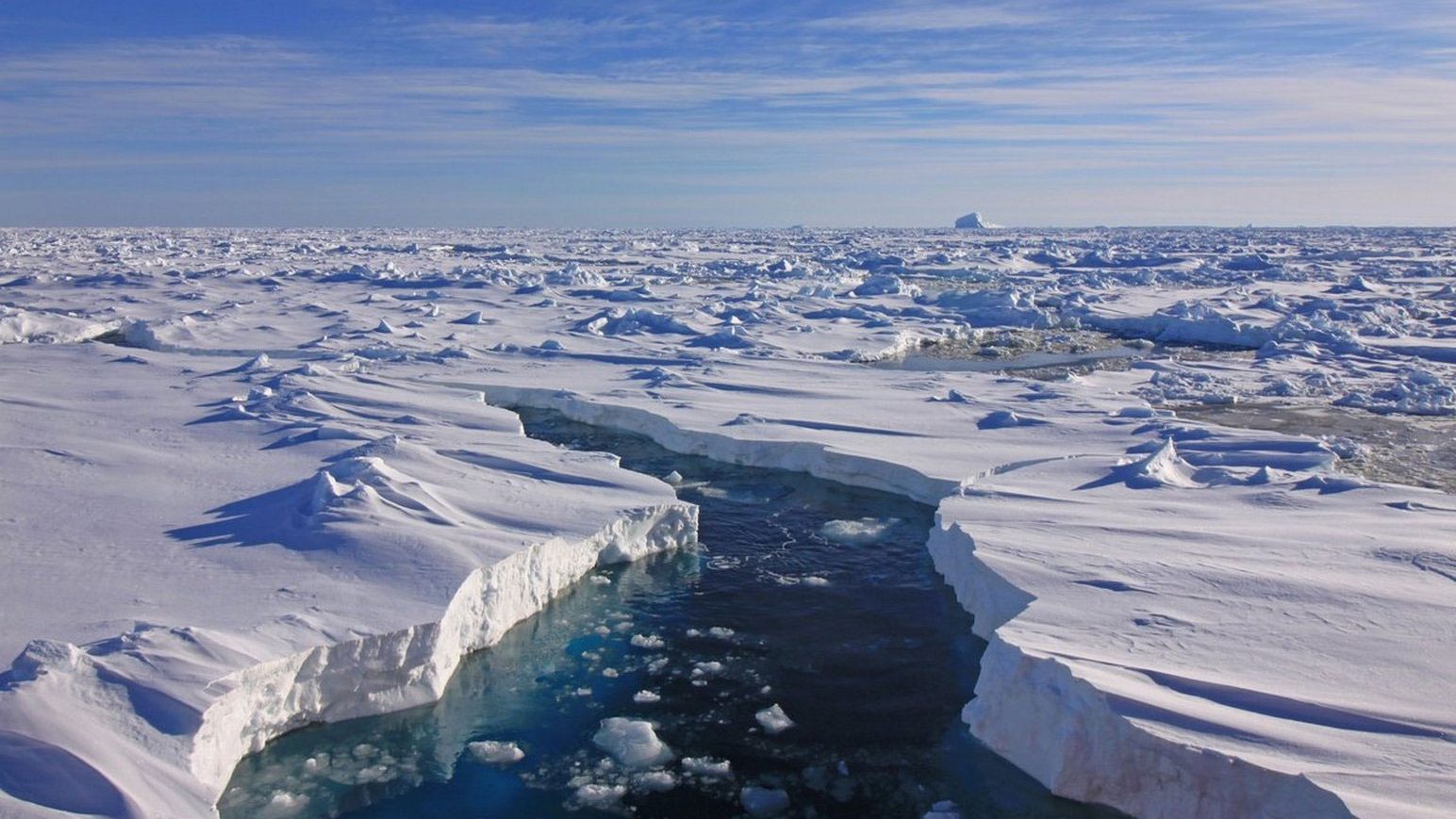
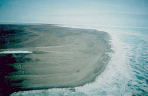
When we descended to commence our survey, the splendid desolation of the Arctic came home. Flying at 200 feet over the white and aquamarine patchwork of the ice-covered ocean, riddled with melt pools as summer breakup quickly approached, we had only the shadow of the aircraft for company. The low islands, little more than gravel and sand dunes, rarely exceeded fifteen feet in height. Sweeping over them, one could not help but pity anyone forced to fight for survival on this barren terrain. As we roared overhead, the seals, peacefully sleeping in the sun near their breathing holes, slipped into the safety of their under-ice domain to escape this strange southern bird. I could not help thinking that before the day was over, some would probably swim within sight of the wreck we were seeking.
I had little to do besides sightseeing. Even though the landscape was uninspiring, I was glued to the viewport as we roared over the geographical features I only knew from charts or my research – Kirkwall Island, Grant Point, and Sherman Inlet all became real to me. The actual survey, like most missions, expertly and professionally done, soon became routine. Taking turns at the controls, the three pilots skillfully flew the lines while the navigators kept up a constant stream of navigational advice “on track, drifting left, on, five right.” Even after seven hours of continuous on-task time, it was rare to hear of a diversion from the track of more than ten meters. This awe-inspiring display of airmanship impressed even an old submariner like me (who was trained to loathe and fear all Aurora crews).
As the mission wore on, it became apparent that we would not complete the survey box I had laid out in advance. I had been given one day’s mission time but had underestimated the time it would take to mobilize and transit to and from Yellowknife. Even so, I was quite pleased with the coverage we had obtained, which I felt was over the most-probable area for the wreck. On the long flight back to base, Scott and Major Sarich went into conference with Brad, and I fully expected as Scott walked back to me that he would tell me we were finished. I was therefore overjoyed to find that the crew’s orders had been redrafted to allow them to complete the mission – we would come back tomorrow!
That night as the crew mustered in the hotel restaurant, I was still pleased that I had been privileged to join the crew and was offered another day. I laid my credit card on the bar and informed the multitude (this Aurora crew numbered 23!) that “the drinks were on the submariner!” It had been a long day, and I knew that the pilots were under a rigorous alcohol regime, so I figured I could get away with one round – these were airmen, after all, not heavy-drinking Navy types. After a costly lesson, we mustered at the aircraft early the following day to do it all over again. I seemed to be the only one worse for wear and repaired to my perch with two bottles of tomato juice as everyone else smilingly and competently went about getting the aircraft ready. The flight north and remaining survey were a repeat of the previous day’s work – I barely registered the now-familiar landscape through bloodshot eyes as I checked off the remaining lines on my chartlet.
One could almost sense the ghosts of Franklin’s men looking up and noting with satisfaction that they had not been forgotten. We felt that we were keeping faith with lost comrades and bringing our skills and talents to bear in an attempt to complete a mission for which they had given their lives so long ago.
As the dull brown barren lands passed below the aircraft’s wings on the way home, I felt a little disappointed that it had been so easy. A hangover and a few tedious hours seemed too small a price to pay for such a large prize, and I couldn’t help feeling that we were “cheating” in some way. McClintock had taken two seasons battling the ice to reach the area in 1859, Hall had spent five years living with the Inuit to reach King William Island in 1869, and Schwatka had logged thousands of footsore miles a decade later. For us, it was a two-hour flight, then back to our beds in a comfortable hotel.
Although Brad had warned me that we were searching in one of the most magnetically unfavourable parts of the globe, I had immense faith in his ability to extract the one significant magnetic spike from the background. I was sure that we would find the wreck. With the scientist’s proper caution, Brad managed to use some downtime on a government survey to resample the area again during a flight later in the summer and then set to work doing the complicated computer analysis. In the end, he produced over sixty “targets” of varying quality. However, there were only a handful of high-priority targets, and I was particularly pleased to find a grouping of three in a small area that I felt best fit Puhtoorak’s story.
A few weeks later, a man in coveralls walked into my office and asked me where I would like the “crate” delivered. Not knowing what he was talking about, I followed him outside to his truck and took delivery of a large and heavy box. Opening it on my office floor, I found a photo mosaic of the survey area, which had been carefully constructed from literally hundreds of photos taken from the belly camera of the aircraft. Unrolled to its full extent, the mosaic covered about 300 square feet and must have involved an immense amount of meticulous hand cut-and-paste work for the photo-intelligence division.
The question now arose as to what to do with this data. After a few measurements to confirm the placement of the various islets, I drove the photomosaic to the Canadian Hydrographic Institute in Patricia Bay, where our first discussions set this project in motion. It was gratefully received, if a little uncertainly.
It seemed, however, that our primary purpose remained unfulfilled. The array of magnetic targets posed a thornier problem – there were just too many. Our one quick and dirty trick had failed, and although no one had a viable way to proceed, we agreed that now the “hook was in,” and we couldn’t give up.