PROJECT SUPUNGER – POST EXPEDITION REPORT (Woodman)
General:
Project Supunger was conducted as an exploratory/surveying expedition on the northwest coast of King William Island NWT in June 1995. Organized with the official and financial sponsorship of the Royal Canadian Geographical Society, the expedition was led by Mr. Steven Trafton, with detachments led by Dr. George Hobson and David Woodman. The expedition was planned as a continuation of work done by Trafton in 1989 and by Hobson/Woodman in 1994 toward a scientific survey of the most important Franklin sites on northern King William Island. The most prominent known sites would be revisited. A detailed survey, using GPS (Global Positioning System), of any vestiges of human activity (cairns, caches, tent rings) in the area would be undertaken.
Although logistically organized and funded as a unit, each field group had different objectives and would operate semi-independently. The Trafton group was to search the Clarence Islands for a cairn spoken of in Inuit oral tradition as having been built by white men. The Hobson party would search the Cape Felix area, concentrating on mapping the “summer camp” at Wall Bay and the places associated with various cairns discovered by Schwatka. The Woodman party would search the coastline from Wall Bay to Crozier’s Landing to attempt to identify the site spoken of by the hunter Supunger in 1868, where something was buried ashore. All parties achieved their search objectives, although neither the Trafton nor Woodman parties discovered the cairns/caches they sought.
The Hobson and Woodman parties, consisting of 6 persons, flew from Cambridge Bay to a site south of Cape Felix (69 52.09N 97 55.03 W) on 19 June. The Trafton party flew directly to the Clarence Islands the next day.
Organization:
The expedition was organized on behalf of the Royal Canadian Geographical Society (RCGS). Major financial sponsors were the RCGS, NWT Air, and Adlair Aviation. Other support, in equipment or subsidized products, came from the Polar Continental Shelf Project and Harvest Foodworks (Smith Falls, Ont).
The in-field party consisted of the following:
Trafton Party:
Mr. Steven Trafton (leader)
Mr. John Trafton
Mr. Al Errington
Mrs. Ann Errington
Hobson Party:
Dr. George Hobson (leader)
Dr. Margaret Bertulli (archaeologist)
Mr. Tom Gross
Woodman Party:
Mr. David Woodman (leader)
Mr. Richard Hammer
Mr. James Garnett
Two other planned participants (one Hobson party and one Woodman party) could not participate due to other commitments. All personnel were unpaid volunteers and were self-sponsoring.
Logistics:
The expedition flew to and from Cambridge Bay with NWT Air and deployed to the field with Adlair Aviation. Food and equipment were provided for 120 person-days with a 25% over the allowance of food for contingencies. Communications were maintained with Polar Continental Shelf (Resolute) on HF radio, with a daily check-in by the Hobson party. Daily VHF communications between the Woodman and Hobson parties were planned using portable radios and Yagi antennae. This was successful only three times during the two weeks of the expedition. Emergency food, flares, and first-aid equipment were provided.
Environmental:
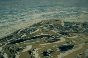
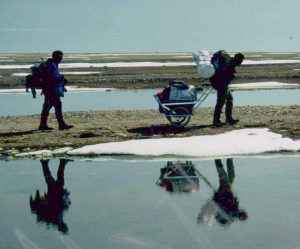
The northwest coast of King William Island is remarkably desolate. The week prior to arrival had been unusually sunny and hot, and the snow cover was reduced to scattered patches. All low-lying areas were very wet, ankle-deep standing water being common when not on raised ridges or beaches. Along the coast, raised gravel beaches offered better walking.
Temperatures during the expedition (19 June – 1 July) were moderate (approximately 0° C to 15° C with average temperatures of about 5° C). Winds were predominantly North or Northwesterly, although they were also experienced from every other direction. There were two periods of light rain and very brief snow flurries. There was one windstorm of 30+ knots, although there was an almost constant wind of 10-15 knots. The last three days saw extended periods of calm, sunny weather.
Animal life was very scarce. The Woodman detachment members noted approximately five seals, 5 Musk-oxen, and two caribou, in addition to birds (killdeer, ptarmigan, geese).
Results:
The expedition did not find evidence supporting Supunger’s story of “vaults” or structures in the indicated area. This does not necessarily discount Supunger’s testimony as the search was not comprehensive enough to show that Supunger’s structures do not exist in this area. Most of the likely beaches were searched to a distance of 1/4 mile inshore, but the inherent difficulty in travel (which reduced available search time) and the limitations imposed by a three-person crew allowed only a cursory investigation of most sites.
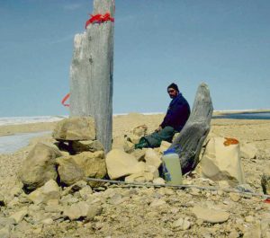
The expedition located various cairns or caches of uncertain origin. Only two of these are worthy of note, one where some remains of tin cans were found (see below) and a large campsite on the first beach immediately south of the river which lies to the north of Victory Point (approximately 69 40N, 98 17.7W). At the last place, there is obvious evidence of many visits by Inuit, and some more regularly-shaped structures may also indicate the site’s use by white men. No artifacts were found here.
Cape Maria Louisa
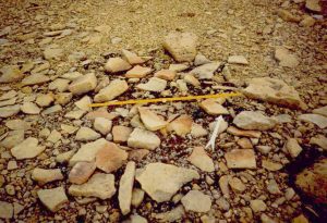
On 24 June, a campsite was found at 69 46.665N 98 13.1W, about one mile north of Cape Maria Louisa. This consisted of the remains of a cairn, a possible fireplace, and some surface artifacts including one can and three lids. It is uncertain whether the associated campsite was built by the Franklin crews. Hobson and McClintock mention the simple discovery of two Franklin-party cairns between Cape Felix and Crozier’s Landing (1859), although neither gives any details. Twenty years later, Schwatka’s party found one native-built cairn in the vicinity:
The boy Awanak found an old Innuit cache of relics on the point, just south of Cape Maria Louisa. It contained a small barrel canteen, marked on one side No. 6, on the other G.P. and the Queen’s broad arrow, a ship carpenter’s ax also stamped with the royal arrow, a small (gallon) wooden keg with iron handle and shield and the latter branded “3”, a two gallon tin oil can with brass shield labelled J. “Gowen, Ironmonger, Woolwich,” and a few other less important relics. (Stackpole, 84-5)
Schwatka’s companion Gilder gives essentially the same report of the cache found by “Owanork,” found on a point “below Cape Maria Louisa.” However, he remembers the canteen as marked “No. 3” and “G.B.,” and mentions in addition “a tin powder can and several red cans marked GOLDNER’S PATENT” and some broken wine and port bottles. (Gilder, 147-8) It was both Schwatka’s and Gilder’s opinion, expressed by the latter, that “the cache was one evidently made by Netchillik Innuits, who had found the things along the coast. In fact, one of those we had interviewed mentioned having cached just such articles somewhere along the coast, and had afterward forgotten the place.” (Gilder, 148) The campsite discovered by us a few miles to the north may have been the source of the cached articles found by the Schwatka party.
The surviving tin can was of heavy gauge metal, 6 3/4″ in diameter and 3 3/4″ high. It was formed of two bent rectangular sheets of unequal length (about three times longer than the other) soldered together to form a cylinder. This, in turn, was closed at each end by a circular piece folded over the cylinder and roughly soldered on the outside.
A large blob of solder was found on the outside of the tin opposite the vertical joints, and the soldering was generally of a very sloppy nature. This tin was without a lid, and three small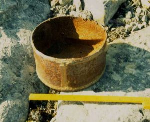 holes in the bottom may have been punched through with a sharp instrument.
Nearby were found three tin lids which would have fitted the tin found. Each showed evidence of a vent hole closed with solder in two stages. The initial hole was covered with a metal washer which itself had a small hole in it. This hole was then closed off with another application of solder. The lids had been removed by a chisel or other such implement with a blade about 3/16″ long, as evidenced by the pattern around the rim.
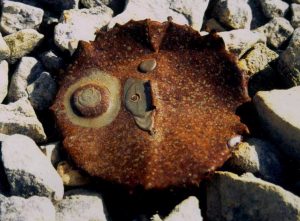
Each lid had a lifting ring of a “D” pattern soldered to the center. A stamp had been used in this solder to mark the tins either “6” or “9” before the solder solidified. Interestingly, Schwatka noted that one of his finds was also stamped “6” (although Gilder, confusingly, stated that it was stamped “3”). This imprint was still evident. There were no traces of paint or adhesive substance on the tin or lids.
Conclusion:
PROJECT SUPUNGER ’94 demonstrated that the structures spoken of by Supunger to Hall do not exist to the south of Crozier’s Landing. The Woodman detachment of SUPUNGER ’95 similarly demonstrated that the structures do not exist, in any immediately apparent form, along the coast between Wall Bay and Crozier’s Landing. The possibility exists that the “vaults” spoken of may be found along this latter stretch of coast, but a much more extensive and more comprehensive search would be required to discover them.
The two sites identified above (C. Maria Louisa and S. of the river immediately to the north of Victory Point) may repay more extensive investigation by parties which can devote the time and attention required to search these sites meticulously.