Two Words
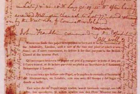
The “Victory Point Record” is the bedrock on which a ny reconstruction of what happened to the doomed Franklin expedition must rest. This most significant surviving document left ashore on King William Island was found by Lieutenant William R. Hobson of McClintock’s expedition in search of the lost expedition.
The significance comes from the handwritten notes in the margins of the printed form, mainly written by Commander Fitzjames, with a short handwritten postscript by Captain Crozier.
It can be summarized by its beginning and ending lines:
Fitzjames: “HM Ships Terror and Erebus were deserted on the 22nd April 5 leagues NNW of this …” Crozier: “and start tomorrow, 26th, for Backs Fish River.”
Even in this seemingly precise and exact short extract, two words, perhaps the most important ones, require further elaboration – “deserted” and “for.” Fitzjames’ use of the word “desert,” or Crozier’s mental state when he wrote that his men would “start tomorrow, 26th, for Backs Fish River,” is uncertain. We should consider what Franklin’s officers might have intended to convey. Modern historians might not understand these two words in the sense that was used at the time.
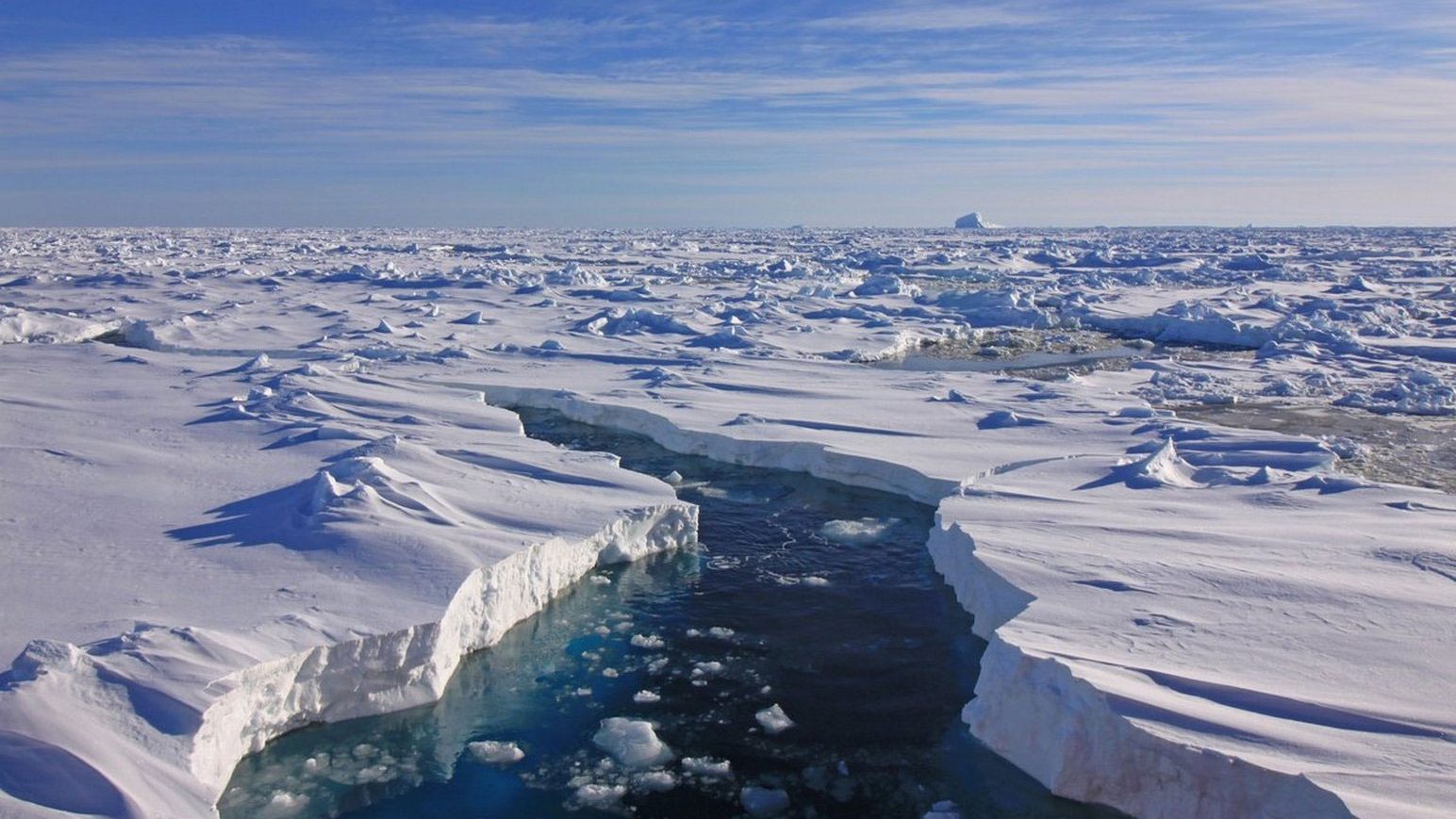
It is often assumed that when Crozier’s men left the two ships in the ice of Victoria Strait, they were on a one-way trip, never intending to return, and that the Great Fish (now Back) River was their ultimate destination. Neither reading is straightforward.
“Deserted”
Non-mariners often miss the significance of the use of the word “deserted” in this context, and writers commonly substitute, inaccurately, the modern synonym “abandoned.” Yet these terms have specific meanings. According to the Cambridge Dictionary, the adjective “deserted” means “there are no people in it.” Abandoned is subtly different – “left in a particular place or condition, usually forever.” If your vehicle breaks down on the highway, you might desert it to go in search of a mechanic. You intend to return with a tow truck and retrieve it. If you fail to return, and it becomes a weed-infested roadside wreck, it has been abandoned and is no longer fit for use.
This distinction was more pronounced when Fitzjames wrote: “deserted.” As a mariner the difference would have been even clearer – one “abandons” a sinking ship without thought of returning, the order is never given to “desert” it. The Fury, broken onshore, was “abandoned,” as was Ross’ Victory which was badly leaking and unseaworthy. Shackleton wrote of his Endurance, “We have been compelled to abandon the ship, which is crushed beyond all hope of ever being righted.” The ship had been destroyed, it was reduced to a broken mass of timbers and debris.
Any Captain, especially a naval one, is very reluctant to abandon their ship. In the Navy, it was automatic grounds for Court Martial. During the mid-nineteenth century, a particular example is presented by the case of Belcher’s Franklin search squadron of 1850-4. Belcher’s decision to leave behind four of his five ships locked in ice, even though undamaged, was a major controversy.
Belcher’s instructions to his subordinates were equivocal. His orders to HMS Resolute’s Captain Kellett tried to parse the meaning of abandon, “you are at liberty to determine … whether you will leave the Resolute or Intrepid as a depot. One must be left.” The implication here was that the ship was to be left intact and seaworthy. He further muddied the water by continuing that the ships might be left “with or without a crew.” This caused Kellett to respond, “You really have given me no orders that I could act on … if it was your direction that I should abandon my ship, both vessels, all would have been well with me, and you would have had me with you.”
Similarly, McClintock, commanding HMS Intrepid, when ordered by Belcher to leave, wrote, “this abandonment goes mightily against the grain. If we could save even Intrepid, it would be something … If new crews are sent from England to hold North Star, then a party could proceed back to extricate one or both. Strike topmasts, and get everything on deck.” Although Belcher’s orders to his four Captains used the word “abandon,” he made clear what he meant, “upon the matter of abandonment, my orders are explicit, merely the withdrawal of crews … leaving the vessels in a condition to be re-occupied” – i.e. desertion.
That desertion was the correct contemporary term is shown by Lieutenant Pim, who, when he arrived on board the Resolute, remarked, “The ship seemed almost deserted, two or three officers only on board … Dr. Domville was at the Investigator, at Banks Land, holding a medical survey of her crew … His report would decide the steps to be taken with regard to remaining by or deserting that ship.”
One determining factor that usually differentiated between the terms desertion and abandonment was the condition of the ships. Fitzjames’ use of the term “deserted” indicated that the ships were left intact and seaworthy. It is curious that nowhere in the written additions to the Victory Point record, which deals with minutiae like the location of James Ross’ cairn, is there any mention of damage to one or other ship.
The Inuit described the wreck of both of the Franklin vessels. One was apparently crushed in the ice to the west of King William Island, while the other, later found far to the south at “Utjulik,” was discovered in perfect condition – boats at the davits, all the doors locked, housed over with sails – as if left in winter quarters. It seems that there was at least a possibility of the men returning to the ships if their intended march to the south failed. But did they?
The return to the ships of at least part of the crew during the summer of 1848 is not a new idea. The first to consider the question was McClintock himself, who, while examining the boat and sledge in Erebus Bay, was “astonished to find that the sledges were directed to the NE.” Although the boat and sledge were “barely, if at all, above the reach of occasional tides,” McClintock remarked that “my opinion, formed on the spot in 1859, was that this boat and sledge could not possibly have floated into the position in which I saw them” and that “a little reflection led me to satisfy to my own mind at least, that the boat was returning to the ships.”
Even stronger evidence for this came from the curious detail of Lieutenant Irving’s grave discovered by Schwatka’s expedition at Crozier’s Landing. Schwatka noted that the body within was encased in “many pieces of coarsely stitched canvas, showing that this had been used as a receptacle for the body when interred. From this fact, I inferred that the body had never been buried from the ships, where sufficient work … could have been procured to construct a coffin; but that Lieut. Irving belonged to a party that had returned to the ships, after it had become evident that all could not escape.”
McClintock agreed with this assessment and noted, “we learn from the Franklin Record itself how Irving had found and conveyed it to Point Victory, from the spot, about four miles[i] to the northward, where Commander Gore had deposited it a year previously. It is therefore reasonable to suppose that Irving had been sent to look for it, and that he was at that time amongst the strongest of the few remaining officers.” He concluded that “it is impossible to believe that [Irving] died and was buried within the few hours which elapsed between the deposition of the record and the starting of the crews for Back’s River … To account for Irving’s grave being in this place, it is necessary to assume that he returned with a party making its way back to the ships.”
Another surprising fact that led McClintock to the conclusion that some men had regained the ship was the detail that “the body of a man was found on board the ship.” As the Victory Point record unequivocally stated that all of the remaining 105 survivors had left the ship in 1848, the presence of a dead body onboard is otherwise inexplicable. This was a persistent element of the Inuit tradition. Charles Francis Hall learned that the ship was found “all complete & one man aboard … The man aboard a very large man. It took 5 Innuits to lift him. His teeth long as an Innuits finger & of a very great stature.” Another informant recalled that the large dead white man was a “very tall man. There was flesh about this dead man that is, his remains quite perfect … His place smell very bad. His clothes all on – Found dead on the floor.”
Not only did the Inuit find this dead man on the southern ship, but initially, “the people thought they saw whites on board,” and when they eventually entered the ship, “every appearance somebody had been living there.” There seemed to be many traces of recent activity. The Inuit hunters found that a plank “extended from the ship’s side down to the ice,” and “fresh tracks were seen of four men and a dog on the land where the ship was.” A pile of dirt was found “on one side of the cabin door showing that some white man had recently swept out the cabin,” and they “saw scrapings and sweepings alongside, which seemed to have been brushed off by people who had been living on board.” Such traces could not have survived a long drift in moving pack ice. Indeed, the ship, when discovered, was enclosed in “new ice” (one winter old).
Taken as a whole, it seems apparent that the Franklin vessels were not “abandoned” but “deserted.” McClintock’s opinion that at least some portion of the crew returned to them, usually dismissed by historians, is strongly corroborated by Inuit testimony.
“For”
The second significant word on the Victory Point record, Crozier’s “for,” also has maritime connotations. When I was training as a Navy navigator and tasked with filling in the ship’s official log, I was instructed to use “for” to indicate the direction of travel. One departed Vancouver “for” Singapore, not “to” Singapore. Any voyage is uncertain, and “to” was deemed too presumptuous – challenging fate and the sea to divert or prevent your arrival.
Most historians do not take the Great Fish River as Crozier’s ultimate destination. In their analysis, this was just a first step in his survival plan, and it is usually thought that he intended to take his men up that river toward help that would be found at a Hudson’s Bay fort on Great Slave Lake.
In 1833 George Back, the first explorer to travel the river that now bears his name, described it as “running through an iron-ribbed country … broken into falls, cascades, and rapids, to the number of no less than eighty-three.” This was not Back’s first experience of difficult travel through the “barren lands.” he had been Franklin’s subordinate during the 1819 expedition to explore the Coppermine River, where 11 of the party of 22 died. Franklin would undoubtedly have discussed the difficulties of overland travel with Crozier (both of whom personally knew Back).
When consulted as to the best place to look for Franklin’s missing crews Back was emphatic. He wholly rejected “all and every idea of any attempts on the part of Sir John Franklin to send boats or detachments over the ice to any point of the mainland eastward of the Mackenzie River, because I can say from experience that no toilworn and exhausted party could have the least chance of existence by going there.”
Contemporaries agreed with him. James Clark Ross was sure that Franklin’s “intimate knowledge of the impossibility of ascending the Great Fish River, or of procuring food for his large party when crossing the Barren Grounds, would prevent his going there.” John Rae believed “that the fearful sufferings undergone by Franklin and his companions, Richardson and Back, on a former short journey through those barren grounds, would have deterred inexperienced men from attempting such a thing.”
It seems manifestly impractical for Crozier’s one hundred and five men to ascend the five hundred and thirty geographical miles to the nearest shelter after having already traversed one hundred and fifty miles to reach the mouth of that river from the location of the ships. Back’s ten-man party had needed forty-two days to travel the river alone. Most estimates agree that Crozier could have transported thirty days of provisions for his men at most. Knowing the distance to the mouth of the Great Fish River, Crozier must have realized that it was not likely that his men could reach it, much less ascend it to safety.
What is usually missing from discussions about Crozier’s supposed plans to reach an HBC establishment is a description of what he would, if successful, find at either place. At that time, there were only two alternatives on Great Slave Lake – Fort Reliance or Fort Resolution. Although grandly named “fort,” these would not provide safe and welcoming destinations for one hundred weary, sick, starving men.
Fort Reliance was built in 1833 on the easternmost edge of Great Slave Lake, specifically to serve as a temporary base of operations for Back. Three houses were ranged around a square, the main one measuring thirty by fifty feet. Rapidly built for temporary use, the structures were not particularly robust (although the remains of the four stone fireplaces with their wattle and daub chimneys still exist). After his four-month journey to the ocean, Back found that the main building had tilted and the mud plaster had washed away. Crozier would have been aware that the site was abandoned in 1835.
Fort Resolution was two hundred miles further along the lake’s south shore. Built in 1819, this is the oldest continuously-occupied place in the Northwest Territories. It became the principal fur trade post on Great Slave Lake in 1821. It was still little more than a small trading post, described by Back as “a house with a few miserable stockades.”
The manifest difficulty, almost impossibility, of reaching the mouth of the Great Fish River, much less ascending it, forces us to re-evaluate Crozier’s stated intention to start “for” it. Even if he had decided on this impractical solution, he would have known that there was little comfort or relief waiting for his men at distant and spartan HBC establishments. So what was he thinking? The Victory Point Record tells us where the Franklin men were headed, it does not mention why. John Rae, the first to learn of their fate, was told that “they were then going to where they expected to find deer to shoot.”
The published accounts of prior explorers are known to have been included in the libraries of the Franklin ships, and they were probably extensively used to plan the details of the intended retreat from the ships. Crozier would undoubtedly have been aware of Back’s account and the later one of Thomas Simpson, each of which could provide clues as to why he was heading south.
In 1839 Simpson had reached the southern shore of King William Island, arriving at a point “only fifty seven miles from Captain James Ross’ Pillar.” This was well within range of the men from the beset Erebus and Terror. Here Simpson found a country “abounding in reindeer, musk-cattle, and old native encampments. To seaward a good deal of ice appeared, and vast numbers of snow-geese passed high overhead in long triangular flights, bound for milder skies.” To men, perhaps already noting the inroads of scurvy and about to reach the limits of their provisioning, such a source of fresh meat would have seemed like possible salvation.
Just as enticing would be the “old native encampments” found in the area. If Crozier had only intended to supplement his larder, he would presumably have sent a large hunting party of his strongest men south. Still, he took all of his surviving men. Perhaps he felt that the greatest chance of survival was to connect with local Inuit, who could provide food and, more importantly, pass word as to his party’s location and predicament. In Back’s 1833 account, Crozier would read of a large band of friendly Utkuhikjalingmiut Inuit encamped at Lake Franklin, a short distance from the Great Fish River’s mouth. Even more than the prospects of hunting, the potential of meeting supporting Inuit would have been critical.
The Victory Point record is a snapshot of the expedition as it lived through early April 1848. A close reading might indicate what Crozier and his officers had planned. It gives little information about what actually transpired in the coming months or even years.
There is no evidence that any of the marching men actually reached Chantrey Inlet, much less the mouth of the river that empties into it. In fact, when met by Inuit on the south coast, their intended destination had changed to “Iwillik” – Repulse Bay. During the same encounter, the leader indicated that at least one of the ships had been destroyed by ice, something that he could not know in April 1848. Even if the Inuit tales of a manned ship arriving in the south are discounted, and they should not be, this one detail contradicts the standard reconstruction of a single doomed march to the south during spring and summer.
Update [2021]
This essay was written as a “thought piece” before the publication of Unravelling the Franklin Mystery. It was my practice to use these essays to organize evidence and my own thoughts about discrete elements of the overall Franklin expedition. Changes/errors that have emerged since writing include:
- The discovery of the “Utjulik” wreck in 2014 has validated the Inuit tales about its location. So far no evidence has emerged that would indicate that she was entered by the Inuit, although this is to be expected. There is no evidence of significant hull damage from ice or removed planking.
- The discovery of the second wreck spoken of, which turned out to be HMS Terror in 2016, also revealed no evidence of significant damage.
- Neither wreck is in a position that is easily reached by drifting. In the opinion of the discoverers, it seems likely that both were brought to their final position by human action.
- The number of individuals who died at the Erebus Bay camp has multiplied in the last years through forensic and DNA work, from McClintock’s two skeletons to approximately twenty individuals. When this was written, my belief was that the 1848 retreat reached the “hospital camp” in Terror Bay, and that the “boat place” in Erebus Bay, where Hobson and McClintock found the boat, indicated the last resting place of a detachment from the northbound retreating party. With one of the wrecks lying nearby in Terror Bay, this is no longer likely, and it seems more probable that the “boat place” was the furthest extent of the 1848 retreat.
[i] The use of miles is retained throughout, rather than the modern metric system. This is to maintain consistency with quoted material. For conversion to the more modern metric unit kilometer multiply miles by 1.6.