The Utjulik Wreck
©David C. Woodman 2003
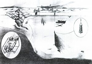
The Utjulingmiut were certain that there had been men aboard the ship when it arrived in their country, and that these men had lived aboard through the winter. Some claimed to have actually seen them moving about on deck. Others had found the strange outward-pointing footprints of three men on the nearby shore. From the distance between the tracks some concluded that the men had been running, others knew that white men were very tall and their tracks were naturally far apart. This is why they were often called “Aglooka” – “strider” since they seemed to always be walking in a hurry. The tracks showed that these men had a dog with them, and the consensus was that they had been ashore hunting caribou.
After many days of watching the ship from a distance the Inuit decided that the white hunters were not returning. The kodlunaq had all gone away, leaving only this treasure ship of wood and iron. They had not been gone long. They had left a plank extending from the vessel’s deck to the new one-year ice. They had, like all sailors, been careful to leave the vessel in perfect order – the deck swept clean of dirt and debris (a little pile of sweepings was found on the ice), and all of the doors locked. There would later be talk of flapping canvas, but whether this was a winter awning stretched over the deck or some sails which had broken loose from their lashings was impossible to determine. The Inuit were not familiar with this white fabric and its uses.
The large umiaq sat there beckoning in its smooth prison of ice. One man raced up to the stern where a large boat hung peacefully in its davits. Excitedly exclaiming what a good meat trough it would make he cut the supporting ropes with his knife, only to watch the boat break into pieces as it fell to the ice. His companions found this very funny. The natives cut a hole in the hull just above the waterline. It was very dark inside, but there was a profusion of useful things, and a great pile of booty soon accumulated on the ice.
The more resolute hunters walked carefully through the ship. In the stern they found a dead man. He was very big and heavy and it took five hunters to lift him. He was lying in a bunk at the back of the ship and he smelled very bad. His teeth were very long (gums recede during extreme scurvy), and he made the Inuit feel sad. There was a wooden board near the head of the bunk. The board was covered in black material, and brass tacks had been imbedded in it in a strange pattern. Some of these were removed, but when the board was shown to white men many years later the remaining ones seemed to make the letters “lf” ([R]IP?).

Throughout the spring the natives returned to the ship and carried off whatever they wanted. Much was left on the ice for later collection, but an early thaw ruined their plans. One day they returned to find the ice had melted and the ship had sunk. Only her mast tops extended above the water. All of the treasure was gone. The more astute among them blamed their comrades for breaking a hole in the hull – that was how the water got in. For a few years boxes and other small things would wash up on the beaches nearby but life soon returned to its normal routines. Within five years the fierce Netsilingmiut band continued its southward expansion and many of the people who had seen the wreck were killed or forced to migrate many miles away from the coast to live with relatives. The Netsilingmiut took over the hunting lands at Utjuliq and heard about the wreck and the strange footprints. They would later tell the old Utjulingmiut stories to the white men who came to their country looking for the missing kodlunaq from long before.
There is little doubt that the wreck being referred to here is one of the two ships taken into the Arctic by Sir John Franklin on his doomed third expedition in search of the Northwest Passage. The expedition left England in May of 1845 aboard two vessels, HM Ships Erebus and Terror. In August they were seen by whalers in Davis Strait, and then they disappeared into the Arctic mists.
One record was recovered from the lost expedition in 1859 which indicated that the two ships were abandoned by all surviving crew on 21 April 1848. On this date they were locked in the ice approximately 15 miles to the west of King William Island. None of the 105 men who struggled ashore survived, and their activities and ultimate fate are imperfectly illuminated by the scant physical remains and vague Inuit stories which were gleaned by searchers in the ensuing century and a half. The remains of the ships have never been found.
Ever since the first interviews with the natives, conducted within a decade of the demise of the expedition, there has been a fascination with the story of the wreck of Franklin’s ships. Behind the natural desire to locate such an important shipwreck lies the hope that the expedition’s officers may have preserved copies of some of their important records (such as were reportedly also deposited ashore) that would illuminate the mystery.
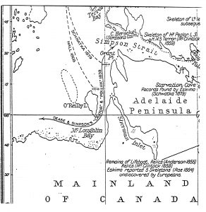
The Inuit had many traditions dealing with the survivors on the march, their camps and bodies, and the final locations of the abandoned ships. The first intelligence of a wreck lying to the west of the Adelaide Peninsula was given to Captain (later Sir) Leopold McClintock in 1859. He was told that a vessel had been driven onto the western shore of “Ootloolik” which he believed to refer to the western shore of King William Island. He assiduously searched that coast without result.
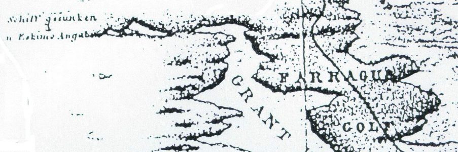
A few years later an American explorer, Charles Francis Hall, interviewed other natives about the vitally important wreck. Hall quickly determined that Utjulik (meaning “the place abounding in bearded seals”) refers to modern Queen Maud Gulf, and specifically to the western side of the Adelaide peninsula. In fact he managed to learn that the wreck actually lay near a small offshore island. An informant produced a rough chart indicating the wrecksite as “Keeweewoo.” This designation may have been more description than name however, for “keeweewook” can be translated as “sunk.” According to the chart this island appears quite large, and lies opposite the entrance of Sherman Inlet.
The only named island in this group at the time was O’Reilly Island, and Hall accepted this as the wreck site. Modern testimony confirms that “a small island to the west of O’Reilly Island is still confidently indicated by the present generation of Eskimos as the spot near which the ship sank.” Hall described elsewhere how his informant, using McClintock’s chart, had “readily pointed out the place where the Franklin ship sank. It was very near O’Reilly Island, a little eastward of the north end of said island, between it and Wilmot and Crampton Bay.”
Memories of the white men are long-lived in the Arctic. In May of 1994 a remembrance was recorded concerning natives who encountered some white men on the march on the Utjuliq shore, “late in the winter, probably around May or June.” Over one hundred years earlier the Inuit had also related that the time of year when the stranger’s footprints were found was “about the middle of May or 1st of June,” and they helpfully remembered that the tracks were seen “at Ook-soo-see-too.” This location was described as being south of “Point C. Grant wh is the Pt. NE of O’Rialy [sic] Island … Ook-soo-see-too the land E of O’Reilly Isle.”
This is all very consistent, the wreck was near O’Reilly Island – the tracks were seen on the mainland shore nearby. But where was O’Reilly Island? We do not have a copy of McClintock’s chart and do not know its accuracy or scale. Nor can we know the exact placement of the native informant’s finger. We also do not know which island in Queen Maud Gulf was named O’Reilly during the late 1800s on the admittedly inaccurate and incomplete charts of the time.
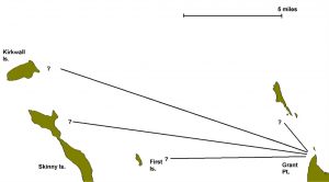
But Hall gave us another clue. He specifically remarked that the wreck “was found by the Oot-joo-lik natives near O’Reilly Island, lat. 68°30’N., long. 99° W.” This is a somewhat confusing statement since the modern O’Reilly Island is about thirty miles to the south of the position as given by Hall. He was one of the most accurate of the Victorian explorers in determining his true position, and we know that he learned of the location of the wreck while encamped at Todd Islets. Hall recorded the position of these islets as 68°23’N, 96°33’W, and this is remarkably accurate, being only about seven miles from its true position. Moreover, most of this error was in longitude (i.e. east-west), which was difficult to determine with the rudimentary navigation equipment available.
The latitude (north-south) co-ordinates which Hall gave for the wreck indicate that he thought that it was seven miles to the north of his current position and about forty-five miles to the west. This would bring him to the western entrance of Simpson Strait in the southern part of what is now Storis Passage. If we ignore Hall’s named identification of “O’Reilly Island” and note simply that he felt the wreck was located to the west of Todd Islets, as noted by his estimate of latitude and longitude, this would place the ship about seven miles to the north-west of modern Grant Point.
The most detailed description of the wreck site was given to the Schwatka expedition (1879). The definitive description of the wrecksite was given by the eyewitness Puhtoorak, who saw the large dead man “in a large ship about eight miles off Grant Point.” Although interviewed nearly thirty years after the event, Puhtoorak’s description of the site was the most specific ever recorded.
Three accounts of this expedition exist, and the relevant sections of Puhtoorak’s testimony in each is reproduced below:
Klutschak – “Only one person, a man of 60-70 years by name of Ikinilik-Petulak, had himself come into contact with one of the [Franklin] expedition’s ships. He was one of the first people to visit a ship which, beset in the ice, drifted with wind and current to a spot west of Grant Point on Adelaide Peninsula, where some islands halted its drift … The credibility of these reports was later enhanced when confirmed by similar statements by others.”
Gilder – “Ikinnelikpatplok [told] of a big ship which was frozen in the ice near an island about five miles due west of Grant Point, on Adelaide Peninsula. They had to walk out about three miles on smooth ice to reach the ship.”
Schwatka – “old Ikinnilik-Puhtoorak … told Ebierbing that the next time he saw a white man was a dead one in a large ship about eight miles off Grant Point … When the ship finally sank her masts stuck out of the water…”
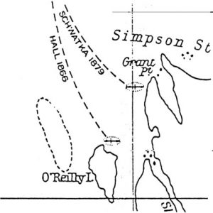
Although these accounts must be used with caution – the descriptions are obviously filtered through European lenses as the Inuit had no conception of either “west” or “miles” – they remain the most specific clues on record. The Inuit accounts do give us a good starting point at Grant Point. They also provide some other clues (“near an island” – water depth < mast height), as well as offering hope that the wreck remains upright on the bottom and fairly well preserved (most of the shore debris later recovered consisted of boxes and small items).
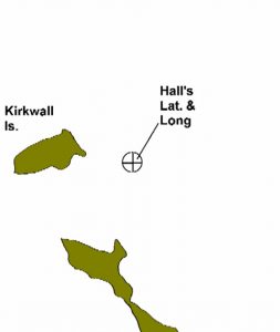
A recent Canadian map (67A Simpson Strait, scale 1:250,000) indicates that there are two islets directly west of Grant Point, one at two miles and one about seven miles distant. These are only two of a group of about ten islands and as many reefs which clutter the area to the south and west of Grant Point and fill Wilmot and Crampton Bay. The northernmost of these is named Kirkwall Island, and, interestingly enough, it is located at 68°30’N., 99°07’W, which is Hall’s exact latitude for the wreck, and only two and a half miles further to the west than he indicated.
It is therefore interesting that the 1994 remembrance of the white men encountered by the Inuit hunters stated the meeting took place “around the Kirkwall Island.”
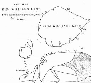
Another piece of evidence favours Kirkwall Island as the location of the wreck. In the 1920s a native labelled a sketch map of the King William Island area. This more modern map does not show any island in Queen Maud Gulf named “Keeweewoo,” but is otherwise quite accurate and detailed. The two most obvious points (Smith and Grant Points) are labelled “tikerqat – the small forefingers,” which is an excellent description. The large island which is now named O’Reilly was called “tajarnerjuaq” by the Inuit as its shape resembled the flipper of a seal. To the north of this last island and to the west of Grant Point/Tikerqat lies an island which was labelled “umiartalik – the place where there is/are umiaq.” The present-day (2001) inhabitants identify this islet as the small tear-shaped one a few miles to the southeast of Kirkwall.
The last word of the native designation is the clue, for “umiaq” is the word which the natives commonly used to designate any vessel larger than the familiar kayak – it was commonly usually used to describe both a whaleboat or a white man’s ship. Again the clue is equivocal, since there are traditions that one of the whaleboats from the Utjulik wreck was found on a small islet nearby and this could have been the origin of the islet’s Inuit name.
The Searches:
The EREBUS and TERROR were robustly built as bomb-ketches and heavily ice-strengthened for Antarctic and Arctic survey work. Traditional stories concerning the circumstances of the sinking of the ship at Utjulik indicated that there was minimum of violence done to the vessel and this fostered the hope that it would still be relatively intact on the bottom.
As we have seen the inherent uncertainty of the Inuit testimony has resulted in two possible wreck sites being identified – one near O’Reilly Island and another to the north near Grant Point. There can, however, be little doubt that the elusive ship lies in the waters to the west of Adelaide Peninsula. Depending on the weight given to each piece of evidence it must lie near, or perhaps between, the two modern islands named O’Reilly and Kirkwall.
In the early 1960s O’Reilly Island was apparently vindicated as the site of the wreck. A small magnetic anomaly was recorded during a magnetometer survey of the area, and proponents of the theory that this was caused by one of Franklin’s ships pointed out that the vessels were each supplied with large iron steam engines (approximately 15 tons, producing 20-25 horsepower), and were sheathed in iron sheeting around their bows. The results of further search were inconclusive, but the geologists concluded that it was “highly unlikely” that one of Franklin’s ships could have caused the reading, and that there was “a very good chance that the anomaly discovered near O’Reilly Island is a meteorite.”
Nevertheless a more detailed survey of the area was ordered and subsequently conducted by Shearer and Roots of the Canadian Department of Mines and Technical Surveys in 1965. Using a sledge-drawn magnetometer, they conducted long traverses at three-hundred-meter intervals to localize the anomaly and then a comprehensive set at one-hundred-meter spacing around the strongest area. They concluded that the anomaly was “purely geological – too big and deep to be manmade” and was probably caused by “iron and manganese deposits in serpentine.”
The 1965 survey was conducted approximately five miles to the north “and a little to the west” of O’Reilly Island, in the vicinity of a small islet which was called “Nail Island” because of a find of “a nail with the navy broad arrow and chips of wood.” The Canadian geologists did find some shore debris that suggested that a ship or ships may have been destroyed in the vicinity, but concluded that the O’Reilly anomaly was simply a red herring.
Another ambitious undertaking was “Project Franklin,” which was organized by the Canadian Armed Forces in 1967 in support of the centennial of Canada’s Confederation. Fifty-two men from various military units undertook an air, land, and sea search of most of the significant locales associated with the Franklin story in an effort to find any relics which still remained. As part of the search, divers explored the sea-bed near O’Reilly Island. The diving teams found nothing underwater, but they recovered some copper sheeting, spice tins, a block, a belaying pin, an oar, and other minor items in beach searches of the northern end of O’Reilly Island and concluded that the pattern of the shore debris suggested a wreck might lie nearby.
Some of this debris might have drifted south from Kirkwall, or been the remains of a ship’s boat which was found by the natives on an unnamed island. Another source of some debris could be a barge that was wrecked in the vicinity of O’Reilly Island in 1926.
In 1992 David Woodman approached the Department of National Defence with a plan to conduct an airborne magnetometer study of the area surrounding Kirkwall Island in the hopes that the wreck’s magnetic signature would be detectable using enhanced anti-submarine sensors. After three days of airborne survey it was found that the area has excessive background magnetic noise, and over sixty “targets” emerged from the analysis of the data obtained. Seven targets within the search area were deemed to have the best characteristics to match a shipwreck. In 1993 two of these targets were investigated without result from the ice surface using a small sidescan sonar dropped through a drilled hole.
In 1997 two survey launches from the Canadian Coastguard icebreaker Laurier spent four days in the area and conducted hydrographic, sonar, and magnetometer surveys of the northern search area. These indicated that four of the seven main 1992 targets were geological (two others were investigated in 2000). The survey did confirm that the general topography of the area was of a flat plain averaging 22m in depth, which was consistent with Inuit traditions that the wreck’s mast(s) briefly extended above the surface after it sank. Also encouraging was the absence of “ice scour” from heavy pressure ridges on the bottom, which indicated that the wreck was probably undisturbed by incursions of heavy ice.
Other results from the 1997 expedition were the discovery of some copper sheeting, presumably from the Franklin wreck, and the bottom of a “Britannia” coffee pot. This type of pot was only issued to Naval expeditions for a brief period in the mid 19th century. A skull was also found and was later determined by photographic analysis to possibly belong to a young Caucasian male and to have been in place for over a century. This skull may corroborate the Inuit accounts that Franklin men from the icebound ship also came ashore at “Ook-soo-see-too” to hunt caribou. Although these finds tend to confirm the southern site each is inconclusive – the normal drift in Queen Maud Gulf is toward the south and the relics were not found in situ but were recovered from abandoned Inuit tent sites.
During the summer of 2000 a five day sonar search of the area was conducted from the RCMP vessel Nadon (temporarily renamed the St. Roch II) during its historic transit of the Northwest Passage. The Nadon, with its shallow draft and stable catamaran design, proved a perfect survey vessel in the uncharted waters, while the escort vessel Simon Fraser provided technical and logistic support. The survey was conducted using the Kongsberg/Simrad SM2000 forward-looking sonar mounted on the side of the Nadon. This high-definition sonar had an effective range of 400 yards, and was able to distinguish bottom features with 2m resolution.
The previously-uncharted ocean bottom in this area was found to be a relatively featureless plain averaging 27m with isolated shoals rising to less than 10 metres on the extensions of shore features and near islands. Four possible targets were found but all were found to be geological. This survey did not produce significant results but eliminated another 52 square kilometer box from the primary search area. In addition shore searches were conducted of Grant Pt. and an outlying island for debris.
In spite of the negative results of the 1997 and 2000 surveys it was still felt that the balance of probabilities favoured the Kirkwall/Grant Pt. area as the location of the wreck and another expedition was organized to continue the magnetometer search in the remaining areas in this vicinity. This survey, conducted in May 2001, was very successful – completing 477 km of survey line and covering over 166 km2 of area, as well as obtaining 109 soundings. This was four times the coverage previously obtained by boat, and proved the efficiency of working by snowmobile over the spring ice.
The 2001 expedition revisited the best hits obtained from the aircraft in 1992 and definitively confirmed (by their extent and shape) that all were geological. Analysis showed that the area had now been covered with sufficient accuracy to preclude “missing” a target with the wreck’s expected characteristics. After software filtering and expert analysis of the raw data collected the results indicated that “seven high-priority anomalies” had been identified. These anomalies had “the correct amplitude and line-shape” for a small wreck. A further fifteen “Priority 2 anomalies” were identified that “generally well-fit the dipole model but … are either noisy or they occur right on the cusp of a geological anomaly which makes their interpretation difficult.” Finally “six areas with short-wavelength anomalies that could, conceivably, be due to a cluster of individual steel components on the wreck” were identified that although not consistent with an intact wreck were included “because they are so unlike the surrounding areas that something “anomalous” must be causing them.”
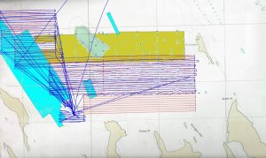
Figure 1: Prior work, this entire area was surveyed by air (1992) and then by boat (1997 – blue, and 2000 – brown), and finally by snowmobile-drawn sled 2001 (blue tracks).
To follow up on the magnetic survey of 2001 another expedition was organized for the following year. The Irish-Canadian Franklin Search Expedition consisted mainly of veterans of the 2001 party supplemented by Mr. Kevin Cronin (the main sponsor) and Mr. John Murray of Crossing the Line Films.
This expedition re-surveyed the priority targets identified near Kirkwall Island at a 50m line spacing for more resolution, and then continued on to the larger search area near O’Reilly Island to conduct an initial area survey at the preliminary 200m line spacing.
The field party spent fourteen days in the Arctic during May operating out of Gjoa Haven, Nunavut. In all the survey completed 1628 km of survey line at an average speed of 10 km/hr and covered 151 km2 of area. Analysis of the data collected eliminated five of the high-probability targets identified in 2001, retained two of those targets for later visual inspection, and located a further six high-priority magnetic anomalies with characteristics consistent with those expected from one of Franklin’s ships in the O’Reilly search area. Some traces of prior Caucasian occupation of the islet used for a base camp (named “Skull Islet from the location of a Franklin-era skull there in 1997). This small featureless islet was confirmed as the “Ook-soo-see-too” of Inuit historical record by our guide Mr. Saul Aksoolak (where white men’s tracks had been seen). Confirmation of prior visits consisted not only of the Caucasian skull (relocated) but by the discovery of a weathered glass “prism” (presumably part of an optical or navigational device) and three tent sites of the typical explorer’s rectangular pattern (as opposed to Inuit tent circles).
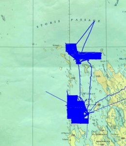
Area covered by the 2002 Irish-Canadian Franklin Search Expedition
Post-expedition analysis of the magnetic data recovered in 2002 revealed that five of the 2001 targets were too large and widespread to be from a small wreck (i.e. – they are the result of geological deposits). One of the remaining northern targets, “Pattern 4,” the most-likely target from 2001 survey, was determined to be “even better” after the high-resolution magnetic survey. In the southern, O’Reilly, area six high-priority magnetic anomalies were found exhibiting characteristics consistent with those expected from one of Franklin’s ships.
Heartened by these positive magnetic results the same team returned to the arctic in May of 2004 on the second Irish-Canadian Franklin Search Expedition. This time they drilled holes through the 2m-thick ice cover and lowered a tethered sidescan sonar through it to get a visual identification of the area around each magnetic target. In spite of detailed sonar survey extending 200m around each target they all were determined to be associated with geological features and no evidence of a wreck was found at any of the locations identified during the 2001 and 2002 surveys. These negative results force the conclusion that, if the wreck is in the area indicated by the Inuit testimony, it does not provide a strong enough magnetic signature to be identified using current technology.
![]()
The Results:
In 1992 the Utjulik search area was a totally unsurveyed 300 km2 box extending the entire length of the Adelaide Peninsula. Seabottom conditions and water depths were unknown, and many islands appeared as “position approximate” or even “existence doubtful” on the charts. Inconclusive testimonial evidence allowed for two alternate readings as to the best location for the wreck – between Grant Point and Kirkwall Is., or to the northeast of O’Reilly Is.
The surveys of 1992, 1997, 2000, and 2001, 2002, and 2004 have completed sonar and magnetic survey of the most likely areas in the northern region, and eliminated the main magnetic targets of the southern region between O’Reilly Island and “Ook-soo-see-too.” This southern area, based on the location of shore debris, the anomalous skull and tent sites, must now be considered the primary search area of the wreck. Although some preliminary sounding and sonar work was done in this area in 1997, and the 2004 sonar results confirm the nature of the sea bottom, it still remains for a detailed and rigorous sonar search of the ocean bottom in this area to either confirm the existence of the wreck or eliminate the area from further consideration.
As sonar work is slow and laborious, and, unless a large vessel is used, is highly dependent on wind and weather conditions during the area’s short open season, it is estimated that between 4-6 seasons of fieldwork would be required to completely survey the southern area.
The Project Utjulik team continues to actively plan and fundraise for continued work in the area.