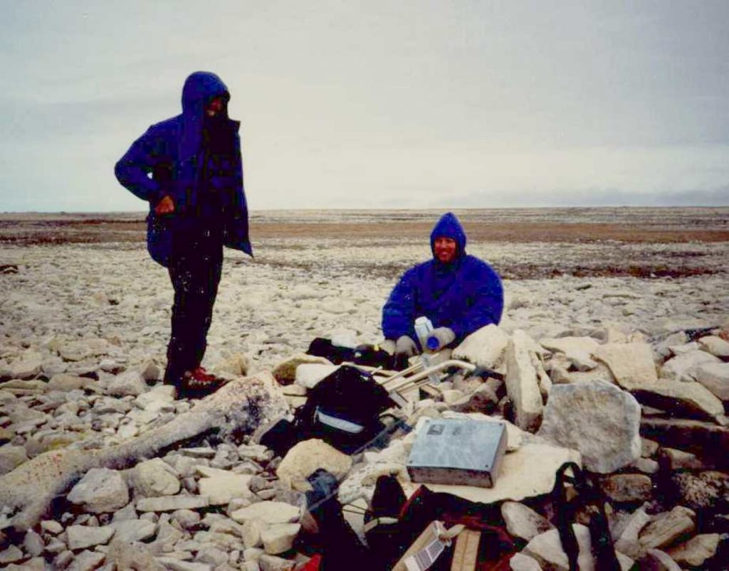
Monday June 19th – Flew Edmonton – Cambridge Bay with stop in Coppermine. Arrived C. Bay about 13:00. Weather fine. After much discussion agreed to fly out with Adlair to KWI this evening. Hobson and Woodman parties will fly out tonight and Trafton party will fly out tomorrow. The flight south is scheduled for June 30th, so try to get T. to commit to pickup on the 29th but he is very indecisive. I make it clear to George, who will have communications, that my party will be ready for pickup on the 29th and thereafter. Land near C. Felix (at 69 52.09N 97 55.03W) about 21:00. Help set up joint camp. Rick, Jim and I decide to try to walk to Cape Felix but are stopped by calf-deep water. None of us have proper boots and we don’t particularly want wet feet. Return to camp (where Jim has flown his kite as a marker) by midnight. Walking is generally good, distance traveled about 4 km.
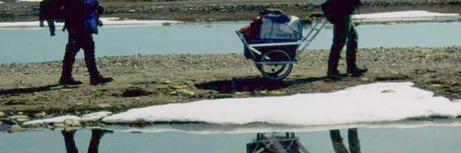
Tuesday June 20th – This is our first movement day. Have a nice breakfast in the big tent with George’s party, we supply the jam. The luxury of the communal 8′ tent is nice, we won’t have this again. We take down our two tents and pack everything onto Rick’s cart. The whole day is taken up in experimenting with different load configurations and pushing/pulling arrangements. Nothing seems to be too easy, we have too much gear! By 13:00 we decide that we must ferry our gear in shifts. Jim and I unload some items and place them in our packs. We proceed on to find a trail. The ground is very wet, still lots of boggy lowlands and snow. At one point J. and I are forced to crawl over a snowpatch after we sink to our thighs. I had to dig my boots out of the icy slush two feet down. Meanwhile R. is fixing the first of two flat tires on the cart. After much back and forth with gear we finally establish Camp 1 at 69 50.08N 97 56.0W. We have had an exhausting and disappointing day and have only made good 2.8 km, although we walked about 6. At this rate we will never reach C. Jane Franklin by the 29th! As we are setting up camp a light rain begins to fall which continues all night. J. and R. remind me that I said it hardly ever rains on KWI. Chili for dinner.
Wednesday June 21 – After yesterday’s experience we have decided to load up our packs and take some of the non-essential gear to a cache on the coast. This will allow us to map out a feasible route for the cart tomorrow. The morning is foggy with visibility < 500 yards. We set out heading generally SW but it seems to take forever to reach the coast, we think that each ridge that we crest will be the last. Finally reach shore at 69 49’N, visibility improves and we have a nice sunny afternoon. The chart shows two rivers emptying to Wall Bay to the south but we find no distinct rivers, only a wide delta of channels. Most are easily crossed, only one requires a diversion inland to shallower water.
Jim and I have rubber boots, but Rick’s ankle boots are too shallow and he gets wet feet. Walking on the beach is relatively easy and our spirits are high. One ice formation off the coast looks amazingly like a polar bear in profile, it was quite disconcerting at first! By 16:00 we establish our cache on the shore about 1 mile to the south of Wall Bay. 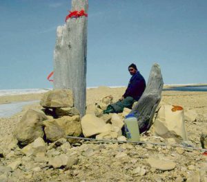 Straight line distance from our camp is 9 km, although nothing is done here in a straight line.
Just inland an inviting ridge leads ENE, directly in line with our Camp. This temptingly looks to afford excellent walking and we call it “the highway.” No-one is excited about retracing our steps the long way back to our tents and dealing again with the wet and muddy Wall Bay delta. This seemingly-easy alternative is too tempting and we set off with empty packs and light hearts. Of course this leap into the geographical unknown proves disastrous – the “highway” ends abruptly, and the next ridge, about 1 mile further north, lies on the other side of a swampy lowland which is feeding the delta at Wall Bay. The crossing of this swamp is the worst two hours of our trip, an exhausting slog through sucking mud, calf-deep water (which is deeper than our boots – we are all now wetfooted) and mushy tundra. Make radio contact with George while standing (and slowly sinking) in bog – they have nothing to report. By 19:00 we are on the ridge where we collapse in exhaustion. I change my socks but it is almost pointless as the felt linings of my boots retains the water. The day is again misty and a strong cold NW wind arrives. We are still 6 km from Camp 1 and it takes 5 hours to reach it. After a soul-killing succession of alternating ridges and swamp we crest the last ridge (according to GPS) and find a large lake where our camp should be. Massive confusion and disappointment. Only when we begin to skirt this lake does Rick see our camp to our left, one tent has been overturned, the kite has ripped away and disappeared in the high wind, and my tent is half-flattened. 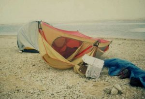 We are all “done in,” Jim walks alone like a robot (he actually walked past the camp unseeing), Rick hobbles into the tent on frozen feet which look frightening, and I have had one of the physically hardest days of my life. Once the tents are re-erected we all disappear into our bags for the night – no dinner tonight. Too exhausted to deal with my clothing and sleeping bag, I simply lay down on my foamy and pull the unzipped bag over me. Deep body shivers, a sign of hypothermia, keep me awake, as do moans from the other tent as they deal with their own issues. Eventually drift off. Distance made good – 9 km, distance traveled – 22 km.
Thursday, 22 June – After yesterday’s experience we are late getting up and very sluggish. We are already two days behind our plan (we were supposed to reach the coast with our camp on Tues!) Our pitiful progress under these conditions, and the debilitating effects of our ordeal yesterday are starting to show that my planned systematic search for the Supunger site is turning into an unproductive ordeal. We consider giving up the search to the south and rejoining George’s party which is less than 3 km to the north, more eyes in a proven productive site may give the best result. We decide to see how today goes, travelling on the beach is much easier maybe we can get the cart and gear to the coast today. Our options to head north to Cape Felix or continue south to Crozier’s Landing will still be open.
The day is clear, cold, and windy. After a “brunch” of Tex-Mex eggs and we are on our way. We leave one tent and the sleeping gear here at Camp 1 and take everything else on the cart. If we are lucky and reach the coast quickly we will come back and recover it, if unlucky we will return to sleep here and bring it on tomorrow. The GPS battery life is poor in the cold, so we decide to adopt Inuit navigational techniques and erect markers (Innookshoo) to show our way. This should also avoid the navigational floundering which we experienced in the trek back to camp yesterday. By 18:00 we reach a distinct mound which offers a certain landmark and a good campsite. Set up Camp 2 at 69 49.256N 98 00.769W. Seven hours of effort and one flat tire today have brought us slightly less than 3 km due west. The site is still 2.2 km from the coast, but we can at least see it now from the top of a sandy hill. We drop our gear here, and try to call George but the radio has switched itself on inside the pack and the batteries are low. No contact. We have a hot meal and begin the trek back to Camp 1 arriving about 22:00. The three of us crowd into the small Moss tent and are immediately asleep. High wind and cold all day but a dry foot day. Distance made good – 2.8 km, distance travelled – 8 km.
Friday, 23 June – This is a 2 phase day. The weather is still windy but visibility is good. We are up early and have a cold granola breakfast as the stove is at Camp 2. Pack up the tent and sleeping gear and set out for Camp 2, reaching it in 4 hours. We knock down the Innookshoos as we pass them for the last time so they don’t confuse future searchers. At Camp 2 we make a hot lunch and shelter from the wind in my tent. Conversation about kids and wives … We have had too short a day to call it quits but we are reluctant to leave this cozy tent and it is 13:30 before we force ourselves out. We decide to fill our packs and take more gear to the cache on the coast. This will also allow us to scout a path from this camp to the beach for the cart. After 45 minutes we are on the shore. We decide to try to cross directly to the south shore of Wall Bay over the ice to save distance and avoid the delta, but are soon stopped by meltpools and wide cracks. When we reach the delta we find that the water level has dropped an inch since we were here yesterday. At this rate it would be a trickle by July. Continue on to the cache, arrive at 16:30 and deposit this second load of gear. The return trip along coast with empty packs in bright sunshine is easy. Although we have not advanced we have transferred a lot of gear today and put in a good effort. Radio contact with George – all well. Reach Camp 2 at 19:40, stroganoff, pilot bread with peanut butter & jam, and mocha coffee for dinner. More talk about kids, J’s incessant bathroom humour. Good day – dry feet. Distance made good – 0 km, distance traveled – 22 km.
Saturday, 24 June – Very bad sleep last night for me, there seems to be a large rock under the middle of my foamy. J remarks about the “Princess and the Pea.” Morning is very cold and windless, the pond is frozen over. Up at 7:15 to make coffee, R & J up at 8. Plan today is to cart all of our remaining gear to the cache. Getting the cart through the delta will be tough.
We are either getting tougher or the terrain is getting easier. We reached the cache with the cart at 15:00, we just powered through the delta. Two flat tires on cart though, one tire (left) is badly deformed and now doesn’t fit properly on the rim. Rick binds it with nylon cord but it still doesn’t look like it will last.
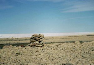
Had a late lunch and decided to continue on. After 30 min rest we set out along coast with cart and loaded packs. Only one trip worth of extra gear left at cache for tomorrow. Good gravel beach, fairly easy going in 15 minute shifts on the cart. A call of nature led me to discover the first possible relics 1 mile north of Cape Maria Louisa today. 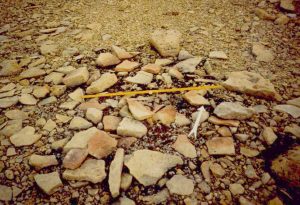 Near a large black rock I came across a rusty tin can, 6 3/4″ in diameter, 4″ high. It was made of very heavy gauge metal, and primitively soldered. It could be Franklin or McClintock (Schwatka didn’t have cans as far as I know). R and J found three lids for similar cans, a broken down cairn, and a probable fireplace nearby. The lids are marked either “6” or “9”. We decide to establish our own Camp 3 (at 69 46.665N 98 13.057W) 100 yards inland of these things to avoid contamination.
 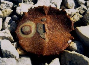 This is the best campsite so far, large rocks forming an enclosed “kitchen” and nice flat gravel for the tent. Find that one of the tent poles is broken, the shock-cord has been cut. Jim manages to “suck” the cord through one section so it can be tied off and we reassemble the sections separately. Big Bill’s Beans & Rice for supper. Most of the day has been sunny and calm but evening brings a strong cold SE wind. Failed to make radio contact with George. We are all in good spirits and excited by our find. Distance made good – 11 km, distance traveled – 15 km.
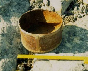
Sunday, 25 June – A very windy night, wind 30-40 knots. Although all three of us are crammed into my tent we barely kept it earthbound. We set up extra guylines halfway up the poles but must therefore leave the fly only half attached and it flapped incessantly all night. Very bad sleep for Rick and I, Jim snored his way through the night though.
At dawn (?) the wind settled down to a steady 10 knots. Day is overcast but visibility is good. After our bad sleep we are late getting out of our bags (8:30) and sluggish at getting going. Multigrain cereal and brown sugar for breakfast. Its 11 before we depart northbound for the cache with empty packs. We return to camp with all the cache gear at 15:00. This is the first time all of our equipment has been in one place since day 2. The map shows two rivers to the south of us, Steve Trafton told me that one of these was the greatest barrier to his 1989 travels and darkly warned about wading waist-deep. We decide to spend the rest of the day scouting a route past these. We find only one river and it is no worse than the delta in Wall Bay. The drainage of KWI is so bad that this is hardly surprising, no river seen yet could claim to be permanent and conditions probably vary month to month much less year to year. Return to camp on higher inland beaches searching for Supunger’s cache. I still think we are too far north. Nothing found, back in camp by 18:30. Good radio contact with George today – he is near Cape Sidney and may have found a new Franklin cairn. Mulligan stew for supper. Dark talk about cutting into my precious foamy to replace the tube in the tire with something more solid but I suggest using lichen and R & J fill our bad tire with it and tie it into shape with nylon cord. The evening is beautiful, no wind, so Jim builds a nice driftwood fire for garbage, and Rick and I each do a full underwear exchange (Jim takes photos). Tomorrow we will try to move our camp further south. Another dry foot day. Distance made good – 12 km, distance traveled – 15 km.
Monday, June 26th – We are up at 7:00. Another cold night, wind is light and the sky is overcast. I make mushroom omelette for breakfast. We decide that we have now used enough food/fuel to manage everything in one load. Cram it all into the packs and load down the cart and we’re off at 11:00. 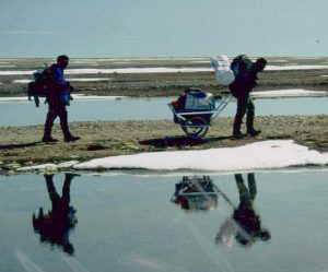 Travel is not bad but full load is still too exhausting and at 13:30 we decide to leave the cart and proceed with pack loads only. At 15:00 we stop for a break and decide to try to reach 5 black rocks on the horizon. Then the rocks start to move around and we realize that they are Musk-oxen! Rather than challenge them we decide to drop our packloads and return for the cart, by 17:20 we are back but the Musk-oxen are still there. During the last two hours both tires have been destroyed and cut off the cart, it is now running on the bare metal rungs and makes a frightful racket. We decide that this, if anything, will scare the animals out of our way so we carry on towards them. The poor beasts never saw or heard anything like us and flee (quite quickly) inland. We come to a small bay filled with ice. As always I suggest crossing over directly but J and R are doubtful. I find a path through the ice, drop my pack and start back to them and they follow reluctantly with the cart. Unfortunately we can’t find my tracks on the hard snow and while I search for them R & J independently flounder about until they reach shore. I have tried a different way and get stopped by a shore lead, they are quite amused as I dart hither and yon now trying to find their trail. Jim tries to make radio contact by calling “Hobson Camp this is Woodman Camp – out” but his bad radio technique is not to blame for lack of contact – dead batteries again. We carry on up to top of the next ridge to make Camp 5 at 69 42.640N 98 16.392W. We are all pretty exhausted by this day, but the sleeping gear is 2 miles north under a tarp back at our rest stop so we must wearily trudge to retrieve it. It is 22:00 by the time we fall into camp. Stroganoff for supper. A beautiful night, very colourful sky, but everyone is too tired to appreciate it. Wet foot day. Distance made good – 21 km, distance traveled – 28 km (a record!).
Tuesday, 27 June – Weather is quite variable today, cloudy, windy and cold in the morning turning sunny in afternoon. We have a late start as we are still tired from yesterday’s exertions. When the wind drops we can clearly hear running water – this is not a good sign. We set off with packs due south from camp. From a ridge we see two large lakes, the westerly one empties into the ocean but from our vantage point we can’t tell whether the two lakes are connected. There is one section which is obscured on the other side of a low patch of bog, we hope there is a land bridge there and walk toward it. Arrive to find that the lakes are connected indeed connected by a channel about 15 yards wide. This river (just north of Victory Point) is not intermittent but is the only one which actually runs through permanent banks. Water depth in the center is impossible to tell, possibly waist deep, but the current is strong and looks treacherous. We can’t cross here, certainly not with equipment. We decide to head east to try to get around the eastern lake. After we ascend the highest ridge we see just how big it is – this is at least a ten mile detour (if it is possible). We reluctantly conclude that we will never reach Cape Jane Franklin on time this way. We are on the top of a good flat ridge – the Twin Otter could land here, so after much discussion we decide to leave our gear here. We will go to the coast and check to see whether the river flattens out into a shallow delta like Wall Bay. If it is impassible then we will move our camp to here and await pickup.
We find the river runs deep between its banks right to the coast. We do find better camp/landing sites on the coastal beaches 1 km north of the river mouth and decide to move camp to that location. We return to Camp 4, load up and retrieve the cart, and shift to Camp 5 at 69 41.612N 98 17.6W. We then trudge across the intervening wetland to the ridge where we deposited our pack-gear this morning and bring it back to the coast. The weather turns sour – windy and cold with a light rain. Wet foot day. No radio contact with George. Bountiful Veggie Pasta for supper. In all we have had a very disappointing day, making good only 3.5 km, while walking 16.
Wednesday, June 28th – A dismal morning, overcast with continuing light rain, visibility is less than 500 yards. My wet socks, boots and windpants left out to dry overnight are all soaked. Bad sleep last night, the first time in two years that I was cold in my sleeping bag. There is no good water at this camp. A few hundred yards away I collect a jugful, but it is very yellow and unappetizing. Everyone is slow getting going today, I get up first, then Rick opens up the tent and emerges. Before he can close the flap Jim races out and sprints 50 feet in his socks for his morning piss, but then goes back in for a little more sleep! Big Bill’s Multigrain cereal for breakfast. The plan today is to try to force our way south with daypacks only, I hope to search all the way to Crozier’s Landing and join our search to that conducted last year. We still have to find a way across/around the river, and decide to check it’s outlet again before committing to the inland roundabout route.
At the river mouth I suggest we try to circle on the sea ice. This is very broken and there are many leads which will force us to go far out. R & J are doubtful. Again I set out alone and find a path. When I am about 1/2 way around after 20 minutes R & J decide to follow but again my tracks are too faint and we find our separate ways ashore. 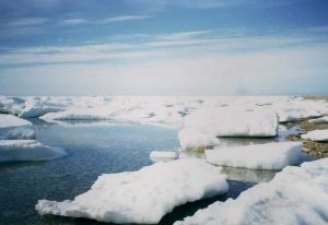 At one point I slip after jumping a wide crack and the contents of my pack – radio, antenna, canteen and lunch, go sliding away. Saved from the deep by about 6 inches. The ice is very solid underfoot, but on one occasion I jump onto a small “island” which bobs disconcertingly under my weight. I am glad to reach solid ground and won’t feel very comfortable until we are north of the river again.
On the first ridge inland from the beach we see a prominent Innookshook and investigation shows that many people have camped here. It is a natural campsite and although many features are undoubtedly Inuit we feel that Franklin’s men would probably have stopped here as well after crossing the river. We search this and all other ridges up to 1/4 mile inland for traces. This is the area which is the most likely for Supunger’s vault. I proceed furthest inland and encounter 2 scrawny caribou. I wonder if they are the same 2 that Walt and I saw last year? By 13:00 we reach Victory Point and have lunch beside the “Franklin Probe” marker. Following the beach we reach Crozier’s Landing at 14:30 and find everything just as it was left last year – tin pieces and can rims are still marked by our little innookshooks (6″ high) and haven’t been disturbed by the ice. Nothing new has been exposed.
Return to camp by retracing our steps along shore and over the ice. Back in camp by 17:30. No radio contact with George again – our last batteries are very weak. Feet sore but dry. Jim has collected some more driftwood for another campfire. Pickup day tomorrow. Distance made good – 0 km, distance traveled – 15 km.
Thursday, 29 June – A cold and windy day, slightly overcast but still good flying weather (we hope). Late and lazy morning as we expect to be picked up by second flight today. I collect more driftwood from the beach for a large fire to burn our garbage, Rick walks over to look at our chosen “runway.” All packed up by noon except for my tent which we will use as a windbreak. So far on the trip I have read 15 pages of my book. Now I read 150. By 18:30 we begin to doubt whether the aircraft will come today. I try to call George on the radio – no luck. We decide to unpack stove and have supper (our last Stroganoff). At 22:00 decide that we won’t be picked up today and turn in. The talk is of family, how we met our wives, how we proposed etc. Everyone is disappointed to still be here, but no-one says anything and spirits are good. Evening is very cold in light wind.
Friday, 30 June – A restless night. Rick thought he heard aircraft at least ten times. We have tickets on the flight from Cambridge Bay to Edmonton today, the flight leaves at 12:30 which means we must be picked up here by 12:00 (11 Cambridge Bay time) to make it. Morning spent repacking gear so that it can be sorted quickly into its Yellowknife and Ottawa packages. Clean everything. The day turns sunny and wind dies – this is the best weather of the trip.
We have missed our flight. I expect some long faces or comments but there is nothing. Everyone carrys on as if it is of the slightest consequence. What a contrast with the bitching last year (when we were picked up only 12 hours late). Good guys.
We theorize why the aircraft is delayed. We hope it is because of a medevac or high priority tasking, perhaps the other party has found something significant and asked for extra time? We hope it is not simply a misunderstanding. We conclude that we will now probably be picked up Sunday for the Monday flight south. Now there is no hurry. We discuss whether we should try to reach our original pickup spot (Cape Jane Franklin) or whether we should stay here. Decide to stay put rather than be caught out in the lowlands miles from a possible landing strip. It would probably take us 3 days to reach C. Jane anyway, we would have to go inland with the cart.
Finished my book today, started on Jim’s Jack London. Jim sleeps all day. Sweet and sour for supper. Again no radio contact, not surprised. Calm beautiful night, talk about our kids and how they learn profanity. Homesickness setting in. Good sleep but back and hips hurt as always.
Saturday, 1 July – Another beautiful sunny day, little wind. Rick makes his famous pancakes for breakfast. Still have about 4 days worth of fuel at normal consumption rate, and lots of food (all stuff we don’t like though). None of us expects to be picked up today. As everything is still packed there is nothing to do except read and sleep. By 16:00 I am too restless and decide to go on a walkabout. I check out the “runway” again and am not as impressed with it as last time. What happens if Ian doesn’t approve of it and refuses to land? Cape Jane is the only sure thing in this regard. I go down to the river to check it again, it seems to have fallen and with the tide out it looks almost manageable. We would still get very wet but it is no longer quite as dangerous.
I return to camp and propose that we try an overnight push to Cape Jane Franklin. I figure that 20 hours of effort would do it, and that the chance of an aircraft after 10 pm is negligible. R and J are unsure, Rick’s ankle is giving him trouble, and he is sure that the chosen landing strip is fine. Both go to have another look and come back with cheering news. They have found another landing strip closer to the beach which actually has Twin Otter tire tracks. Ian will surely accept this one! We decide to stay put.
At 18:30 try for radio contact with George. At 18:40 we hear an aircraft and shortly thereafter see it circling Cape Jane Franklin. It lands (dropping off Coleman party as we later learned) then heads east. Apparently it hasn’t seen us and is heading for Cape Sidney to pick up the others. George and Steve’s parties should fill the aircraft so we don’t expect to be picked up tonight, but we go off and mark our runway with tarps anyway. Jim makes supper and we begin cleanup when the Otter returns. It circles for a while and eventually Ian flies 10 feet over our heads and lands on the beach where we are camped! A mad rush to throw everything into the plane, we are off KWI at 20:00. It seems that the other parties did not find anything too significant either. In Cambridge Bay at 21:30.
We now have two nights to kill while we wait for the Monday flight. At first it seems that we will sleep in the Adlair hanger, but northern hospitality takes over. I will go to the “bunkhouse” with the Trafton party, R and J will be the guests of the Laserichs. Showers and a bunkbed (no linen) are fine with me.