Tuesday, 12th August – Depart Leduc Inn for Edmonton Airport @ 10:30 after some last-minute shopping for laundry detergent and slide film. Flight to Cambridge Bay is uneventful, meet with Jim Bradford and two film guys (Gaudet, Rosborough) during pit-stop at Yellowknife. Arrive CamBay at 15:08 and we are met by John Davis and Rick Haupt with a film crew. The filming starts as we are required to reboard the aircraft and exit for the camera.
Everything has arrived, and there is a van to take us to the dock. We are left standing on the dock for 3 hours as the helicopter from the Laurier conducts a crew-change. Mosquitoes are bad, but this is a good time to get acquainted with Robert (Grenier) and some of the others. Weather is beautiful and I am told that the last ice-map is showing clear water all the way to Gjoa.
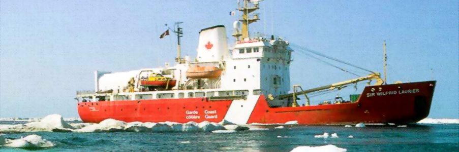
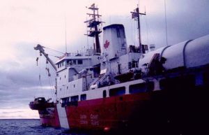
At 18:30 we are picked up and transferred to the anchored Laurier by helicopter. My friend Terry Chillibeck is the pilot! He is filling in for a week until the crew-pilot arrives. I meet Steve Blasco at dinner, my cabin is 617 on the lower deck with John Rosborough (soundman). I will eat in the crew’s mess. After an hour filming the beach and the ship the Laurier departs CamBay at 21:00 for Kirkwall Island. We will arrive on site tomorrow morning.
Wednesday, 13th August – I can’t sleep, and go the bridge at 02:30. Spend a quiet hour with the second mate and his helmsman (Keith, my next-door neighbour on 3 deck). We are abeam Jenny Lind Island but can’t see anything, the land is too low at this distance. No ice, but the “ice-pik” says he can “smell” it. I suspect that he is really basing this on yesterday’s icemap displayed on the bulkhead which shows the ice-edge at the Royal Geographicals, but he doesn’t know that I can read an icemap and wants to impress the “tourist.”
Boat and fire drill this morning after breakfast. The ship’s crew is not quite as polished at this as I would like, and I go into “Captain” mode and can’t help but make a few comments as to how to cross your legs if jumping etc. Must remember that this isn’t my place.
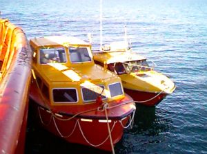
Spend a few hours helping fetch and carry for Bruce [Wile] and Jim [Bradford] who are setting up the equipment on the big launch [“Wind”].
![]()
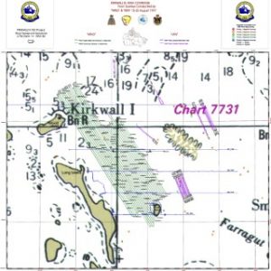
We run into a line of ice, small bits of first year which poses no problem for the Laurier, but will definitely hamper our small boats. The upper deck is full of filmers (including me), JD seems worried, icepik is vindicated. Luckily it is a narrow band and disappears as we approach Kirkwall. Kirkwall is your typical low spit and is very difficult to differentiate from the other islets around it. We come to anchor about 1 1/2 miles to the north of the eastern end, can’t even see Grant Point from here. The size of the area to be searched sinks in.
We commence helicopter operations immediately to set up the DGPS station on Kirkwall. Grenier takes a party ashore to walk the beach searching for debris or artifacts. I go out on the zodiac (Mk 5) with Jack Wilson (hydrographer) hoping to do some preliminary echo-sounder runs, but the sea is too rough for the rubber boat and we return in 45 minutes, wet and unsuccessful. Seas are about 3’, wind is 15-20 kts.
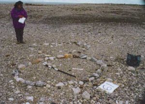
The Kirkwall party returns about 10 o’clock having walked the entire beach around Kirkwall (10 kms?). The film guys aren’t used to this and looked whipped, RG is nonplussed, pours himself a Grand Marnier, and shrugs his shoulders. They found nothing Franklin-related, just a few leg-hold traps and a piece of cast-iron stove (a corner). Also a worked bone implement (toggle? 2 drilled holes) and a disposable diaper.
The DGPS station is set up, but the corrections are not being received on the launches. Antenna problem suspected, the techs are working on it. Not a lot of coordination as everyone is working on their own specialty. Still haven’t met everyone yet, and make the suggestion that JD make up a list of members for our use.
Thurs. Aug. 14th – Up at 6:40. Bright sunshine, wind 15 kts, seas 2’. Yesterday’s lack of sleep has caught up to me and I have a 3-Tylenol headache.
After breakfast the DGPS party returns to Kirkwall by helo (Blasco and Bradford) to move the antennae farther apart. Another shore party is organized (me, JD, Grenier, Chris [Harvey-Clark, biologist], nurse and Dave [Gaudet]). We will search the crown and spine of the island for any sign of the “three cairns” reported in the literature. On the island at 09:00, back at 17:00, found nothing remarkable except some broken down cairns and a few tent circles.
Bradford has managed to solve the DGPS problem (software).
The Captain doesn’t like the exposed position of this anchorage and decides to shift ship, we would like to get a little closer to the search area to reduce transit time for the launches. At debrief JD floats my proposal to “work the weather rather than the clock” since we are under time pressure. Everyone agrees with this principle. Winds are supposed to drop tomorrow so we will get the launches wet for the first time. Bruce [Bennett] and Jack [Wilson] have been working on the small launch all day trying to sort out various technical problems. They are still not receiving the DGPS.
Pass out copy of my wreck essay to Dave G. who wants to know why we are here. Make another one for the crew’s mess.
Friday, 15th August – Up at 6:15, wind has dropped but there is not as much a reduction in the seastate as we hoped. Morning fog.
Laurier is moved east to 98° 50’W at the southern limit of the known soundings. This saves us miles in transit time.
The WIND is ready, the HOURSTON, is not, so the WIND is launched to run basic bathymetry under the direction of Jack Wilson. Seastate is still high and they take quite a pounding (B & B lose their lunches) but run 3×17-km E/W lines. Depths range overall from 5m – 45m with the shoals all lying in the trend with the “PA” reef on the chart. In general the bottom seems to mirror the exposed islands, and the depths are consistent with what we want.
Bruce Bennett works all day trying to sort out why the HOURSTON is not getting differential corrections. He eventually calls Trimble in Toronto to get the reboot code and gets the DGPS up and running. Hopefully the gremlins are defeated.
My contribution today is to go with RG, JD, and Chris to explore “Skinny Island.” We walk the e. side from south to north (into the wind!). Skinny is a true desert, much more sand than Kirkwall or KWI, tiring walking. Robert is excited by a “village” of 9 tent circles on the extreme southern end, otherwise nothing of significance is found. It is encouraging that to the east we have open water, while to the west there are many grounded pieces of ice, indicating shoals extending through the western archipelago. This tends to confirm our simplifying assumption that the prime search area is between Grant Point and Kirkwall/Skinny.
We return to the ship about 16:30 and the WIND returns shortly thereafter. She has 6” of water in her bilges from a small hull puncture on the port side (probably caused by loading onto her cradle in Victoria). She has been taking on water all day, but the ship’s crew will repair the hole overnight.
At JD’s suggestion, I give a written brief to Rick about the most significant sites on KWI in case we fly over there to film. The more northerly ones (N. of Erebus Bay) are probably too expensive since they would require refuelling at either Gjoa or from a cache. Starvation Cove is a distinct possibility since we need to do a pilot swap on Tuesday anyway and it is basically en-route.
Very sedate evening socially as everyone is bagged from the first full day’s work. On the flight back from dropping us off on Skinny Terry thought he saw some “grave structures” on “First Island” (small islet e. of Skinny, which we flew over “first”). These were checked out by Rick and some film crew and we watch the footage which shows meat caches, traps and the remains of an axe and a “coleman” stove. Robert wants to survey First Island tomorrow.
Set up a “wreck pool” on the bulkhead, and I pick my square. The film crew are doing “cabin shots” this evening.
Saturday, 16 August – Wake up at 6:15 to flat calm! We should be working but there is no urgency and the launches aren’t gone until 09:30. The HOURSTON (Wilson & Bennett) will continue to run the bathymetry lines to the south while the WIND (Blasco, Bradford, Wile) will actually deploy the sidescan and start the survey. They will run NW/SE lines from the reef complex to the west.
The lack of wind means fog, and there will probably be no flying until it burns off (expected about noon). Film crew filming the launch of the boats and a simulated diving/hypothermia sequence put on by Dave and Chris. When the helo gets off we will check the propane tanks on Kirkwall which power the thermal generator for the DGPS station. They will probably last one more day, but we need to check. Then we will visit “First Island” and hopefully the next one east as well (north shore only).
An Aurora overflight at lunchtime is a wash, we can’t see them and the ceiling is too low. We hear them go over though. Fog is thin but persistent. A boring day for the shore parties, reading and watching videos.
HOURSTON returns at 16:30, they take a hot supper out to the WIND which is continuing to work.
Fog finally lifts after supper, but helo ops are confined to a quick trip to Kirkwall to change propane bottles. The original two are still 30% full, but are changed anyway. Fog is still lingering so any extended flight ops are out of the question. Kirkwall party has returned by 20:00.
HOURSTON DGPS is still not working properly. Bruce Bennett is running out of ideas and it looks like Monday before he can call Trimble again. This is a severe blow to cartography but does not preclude sonar searches. What it means is that because of the navigational inexactitude the HOURSTON will have to space their transit lines more closely to get assured overlap.
Crew puts on a Dutch shuffleboard challenge in the mess. I score 17 the first time, 120 after I put on a blindfold and play “Zen shuffleboard.” Full moon tonight, but the nights are already getting darker as winter approaches.
WIND returns at 23:30. They have had an exhausting day but have found nothing except a remarkably flat bottom. They have covered about 12 sq. km starting about 1 km from the e. side of Skinny Island. Every erratic shows clearly, and the only magnetometer hit which was at a shallow depth showed no topographical feature. The HOURSTON’s depth survey shows that we have too much deep water, 30-40m which extends quite close onshore and even past “First” Island to the south. Our hopes that reefs would eliminate some search area are not to be.
With the find of Inuit activity on First Is. there is a party of opinion forming that says that the ship would have come further south than I originally thought. Accepting that the ship was manned, the idea is that they would have approached the islands for shelter (minimal) and to replenish water (more likely). I do not subscribe to this, since the testimony says that the Inuit had to walk 3 miles out on the ice to get to the ships. JD is particularly interested in searching near (and to the south of!) First Island.
So far I am encouraged by the fact that we have not encountered anything that is inconsistent with Puhtoorak’s story. It is somewhat disappointing that the depths are so uniform and deep, I had hoped to be able to eliminate 20-30% of the area as too shallow. It is also sobering to see just how small a percentage of the total area is accomplished by WIND’s 12+ hr survey, at this rate the total high-priority box will take 6-7 days (of perfect weather) and we only have 8 days left! Any side-trip to O’Reilly seems definitely out for this year.
For me this has been an inactive and frustrating day. I have read about 1/3 of my Steven King [Desperation] and spent most of the day waiting like an expectant father for news from the launches.
There has been a major problem with the helicopter – a polarity problem in a charging cable has apparently damaged all but 1 of the helo’s radios and fried the GPS. There are spares aboard, but a natural unwillingness to install them until the root cause is identified with certainty. This is the first time I have seen Kippy without a smile on his face.
Went to bed twice tonight, once for a “staged” cabin shot with me pretending to sleep and John Rosborough pretending to work. This is definitely not “cinema veritee” since John is the one who is always asleep! It is hard not to smile when you are pretending to sleep, I feel like a five year old feigning sleep while my dad checks on me.
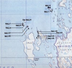
Sunday, 17 August – Another gorgeous day, bright, clear (no fog), and dead calm. Helo is being worked on so there will be no shore parties today. Both launches are away by 09:00, the WIND will continue working to the eastward from yesterday’s area (at JD’s insistence they will extend the lines further southward to cover the vicinity of First Is.) while the HOURSTON starts at the PA reef and works towards the west. The WIND will also run one E/W line over our 3 magnetometer hits. I have predicted that the middle one is the Terror, and that it will be found today between 14:30 and 16:00.
Zodiac is off to Kirkwall again to fiddle with the DGPS station. I am worried that too much effort is/has been expended on this problem, it is time to give up on the HOURSTON’s DGPS and start towing the fish. The HOURSTON is on the water today so I really don’t have a valid complaint. The HOURSTON’s preliminary depth survey yesterday was also useful so we haven’t wasted any time. My personal inactivity is the main source of frustration.
WIND does another long day, a further 12 sq. km box working to the east. Nothing interesting found. The three best magnetometer targets were all geological outcroppings/ridges.
The helo is airworthy again with new parts, so a shore party to First Is. is organized (JD, Chris, RG, Pat, John and me). We set out to measure and map the tent circles, but there are too many of them! We find about 70 in all, and just note the most impressive. One is a perfect circle made with great care (“Frank Lloyd Wright”) and another is made of giant rocks (“Samson”). Robert is quite impressed, but to me “you’ve seen one …”. We use an angle iron marked with gun tape to take an elevation of the highest point of the island (11.25m).
HOURSTON (AKA ERNE, I am informed that Hourston is the maker, the launch’s name is Erne – duh) has done one small area using non-differential GPS at 50m spacing. The problem with non-differential is really brought home by comparing the area covered by the two launches. ERNE can manage only 1/4 the daily survey area done by the WIND. This effectively makes her a “spot check” launch.
No debrief today, big full moon. Watch 1/2 hour of “Fargo.” There is talk that Marg Bertulli might join us from Yellowknife on Tuesday to properly evaluate First Is. tent sites.
Monday, 18th August – Another lovely day, but the Icepik says this will be our last as a cold front is approaching. Again a late start, after a leisurely breakfast and a rather disorganized morning meeting. Today I will join the ERNE crew for “spot checks” on the remaining magnetometer hits from 1992 while WIND continues her methodical survey.
Away from the ship at 10:30, we check area 42 (around anomaly 42, which turns out to be a pinnacle of rock), and area 24 (around anomalies 23/24/38). Nothing is seen on the second box, depths are 30-35m, probably buried geological deposits. The port channel on our sidescan is degraded because of a paper feed problem (alignment/pins). I am impressed by the dedication of the crew wrestling with their hardware problems, but a little dismayed by the amount of “field learning” about the software, which no-one seems too familiar with. We finish running our little box at 22:30. Even though we had no result I am in a good mood just to finally be doing something, even if it is just driving the launch. The WIND has extended the box a further 12 sq km, and is starting to approach the best area. We are about half done here, and I think another 2 days would finish this box.
The helo has taken divers and film crew to an islet about 10 km south of Kirkwall where there was a small patch of shore ice so they could get some under-ice shots. The producers seem happy with the visuals obtained.
Robert and JD returned to First Is. to catalogue sites. A long and boring job which I am glad to have avoided.
The leading edge of the front approaches with sunset (@ 20:30) and it is beginning to get bouncy as we approach the ship. A minor flood from a fresh water tank (through a sounding tube) on the flat outside my cabin door tonight. It is disconcerting to hear running water while lying in bed 3 decks down.
Tuesday, 19 August – Weather has definitely changed. Sleep through my alarm and awake at 07:00 by the ship maneuvering and winch noises. The boats (left out overnight) have been recovered on deck and the vessel is underway for Gjoa Haven for our pilot exchange and to pick up Margaret. Gladman Point ETA is 09:15. Wind is too high for us to be doing survey work anyway, so this diversion doesn’t really cost us anything. The pilot exchange originally was planned as a helo-only operation, but with the technical problems the helo can’t be flown 90 miles from the ship but is only approved for short hops.
I spend an hour on the bridge with the Captain as we transit past Eta Is. The plan is for the Laurier to rendezvous with the Larsen after the pilot exchange to take on some fuel. This will cost us another day as the ships are looking at meeting at Jenny Lind. Capt Webb and I discuss landing a survey party ashore with boats on Aivimilik Is. to make use of this “dead time,” when JD learns of it he explodes and a “free and frank” discussion in the winch control room ensues. We do not part friends.
I do my laundry and write a short letter home for the girls. Terry will take it back to Prince Rupert with him when he leaves today.
When we come abeam of Richardson Point I am told that a party is going to Starvation Cove. I am not specifically invited, and suspect my recent blowup with John has blacklisted me, but at the last minute I am told to get ready. Spend the afternoon at Starvation Cove with RG, Chris, JD, Rick, Bob Guertin. Nothing found (as expected). Adelaide is definitely greener than KWI or the outlying islands, we surprise a “prairie dog” (lemming) who hides under a cache, and we see hundreds of fresh caribou tracks. Picked up by helicopter at 16:30 and transferred to the now westbound Laurier. The plan is now to meet the Larsen at Hat Is. for fuel. The whole operation is expected to take only 12 hours (2 hours transit each way + 8 hours for fuelling) and we should be on site again by noon tomorrow. Not sure which site though, JD obviously prefers O’Reilly to Kirkwall. I make one comment about having only one day’s work to do in the north, perhaps we can send the WIND to complete that box while the ERNE does the preliminary hydrography near O’Reilly.
Margaret is onboard. We have a long talk about Coleman’s trip last year, Ranford, Lyall et al. She gives me an interesting article by David Pelly on Wager Bay oral history.
The plan now seems to be to spend another 2 days to complete the northern area and then decamp to O’Reilly (if nothing found). Robert has contacted Jim Shearer from the 1965 expedition and learned that the nail found on Nail Is. was 7” long. This reinforces his opinion that the wreck is to the south, it must be near the debris no?
Wednesday, 20 August – Wake up to smooth sea and foggy weather. We are anchored at Kirkwall again, since the Larsen and Hanseatic have been delayed by heavy ice in Victoria Strait. It is sobering to realize that if this was 1848 the Erebus and Terror would still be iced in off KWI by the heavy ice in the strait this year.
Margaret and Robert are taken by helo to survey the sites at First Island.
No morning briefing this morning and we finally have a sense of urgency. The launches will continue their work, I will spend another day in the ERNE. We are away by 07:30 but manage to cover only about 2 sq km in area 14 (targets 12/14) despite 10 hours of work. This 50m spacing is tedious and not too productive. Both targets are geological anomalies. Since I am doubtful about our coming back here I convince the guys to spend the last hour running lines in the middle of my “best box.” This means that we do two lines (about 1/2 km by 100m). We find nothing, but the depths here are too deep (avg. 33m vice 22m at area 12) and seem to get even deeper to the NW towards Kirkwall (up to 42m). The Captain wants to leave for the rendezvous at supper time, so we are ordered back to the ship at 16:00. Wind is starting to build rapidly again, and it is an adventure getting up the jumping ladder. Both launches are immediately recovered on deck.
WIND had done another box without result. There is still at least one (more like two) days of work to do to finish this area but it looks unlikely that this will be done.
Marg and Robert have done a full day of site mapping (63 sites, mainly Thule on the higher beaches with recent Inuit on all areas). They have also discovered a skull, which they believe to be Inuit, and some hunting artifacts (a spear head?)
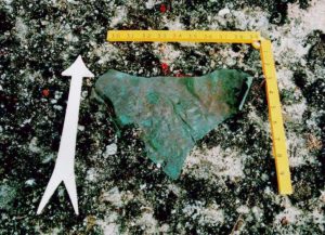
JD and a helicopter party (4 persons) went to north O’Reilly Island and found some artifacts. They recovered a piece of wood which had been shaped into a “tent peg” or toggle, a small (2” x 2”) piece of sheet copper with what appears to be tar adhering to one side, and a piece of yellow-painted wood with square bronze nails on O’Reilly. JD and RG seem very excited about these finds and many theories are advanced. I am not so sure, and sense that the tide has turned away from Kirkwall and towards the secondary site. RG has the usual scientist’s bias against testimony and toward physical evidence, but the bosun later mutters to me that if we wanted to see small bronze nails we could have looked in his garage.
I point out that the only relic which is probably Franklinian is the copper piece, and that it could have been transported by Inuit from anywhere in the area. It also could have come not from the ship, but from the lifeboat which was reported to have been found on an unnamed island in Wilmot and Crampton Bay. I wonder whether the two sites (Kirkwall and O’Reilly) could be the result of the finding of these two “umiaqs” (one ship and one “big boat”) – one at each place.
These relics have turned the tide against Kirkwall. The Laurier will proceed to O’Reilly after tomorrow’s rendezvous with the Larsen. JD is non-committal about whether one launch can be sent north to finish this area while the other works in the south. Again not wanting to lose survey time, I float the idea of leaving the launches behind while the Laurier fuels, and then taking them south to meet the Laurier at O’Reilly after tomorrow’s search. It does not fly.
Have a quick beer and to bed. The jokes are starting to repeat.
Thursday 21 August – Awake to a rather fine day, the predicted storm which appeared to be kicking up yesterday did not materialize. Sunny with a 15 kt wind from the NW and low sea. We are en-route to Hat island to meet the Larsen. Unlike the diversion to Gjoa (which didn’t cost us any search time because of weather), this would have been a working day.
We come alongside Larsen at 08:30, the Captain does a masterful job. Larsen is anchored between Alexandra and Hat Islands (closer to the first). The plan is still to depart at 12:00, suddenly the estimate for fuelling is down to 4 hrs vice the 8 expected. The biggest problem this morning is the loss of the helicopter, the new pilot (Jerry) is unwilling to fly until the GPS/radios can be repaired. Bruce Wile has been called in to lend a hand, and it is hoped that spares can be obtained from the Larsen. The loss of the helo would be a severe blow, we need it to demobilize the DGPS station on Kirkwall and to ferry people to do the shore searches on O’Reilly, Nail, and Johnstone Islands. JD is very preoccupied with this. Eventually a compromise is reached and we get permission to use the helo for short hops again.
We don’t finish fuelling until 14:00 and depart from Larsen. Helo takes off for O’Reilly to recreate yesterday’s artifact find for the film. There is talk of another helo run but no-one seems to know where it is going. No-one has said whether we are returning to Kirkwall or en-route to O’Reilly.
The second helo trip takes RG and film crew to Nail Island. They report finding an oar and the “transom” of a small boat on the shore. The oar is equivocal, it looks too well preserved to be very old but it does have the same square nails found earlier in the piece of wood so most people think it too is Franklinian. JD wonders whether this is the boat which hung off the stern of the wreck and was cut loose by the Inuit. From the description it is not a whaleboat, much too small. The transom will be investigated tomorrow but the helo pilot tells me privately that he thinks that it is probably modern (he says it has “nuts and bolts” perhaps galvanized.)
Unable to bear the uncertainty any longer I go to the bridge and look at the chart. We are following the only line of soundings to O’Reilly. This is quite unnerving and I stay on the bridge, careful to make only small talk to the Captain who is quite chatty. There is one sounding of 3 fathoms ahead, this is our draft so there is some doubt as to whether we will get through. The Captain comes to dead slow as the soundings rise, and eventually we ease into the bottom near the marked shoal. We back off slowly and anchor nearby, directly west of O’Reilly. This is as close as the Laurier will get.
RG is very excited by the shore debris. Steve Blasco and I form the “dissenter’s club” in his cabin over 15-year-old rum and solve all the problems of the world and expedition.
Friday 22 August – A sunny morning, winds 10 kts from the south. Seastate is worse than yesterday (2’) but still workable. Having worked only one day out of the last three has everyone getting restless. We also only have 3 days to go. The plan is to demobilize the DGPS station at Kirkwall by helicopter and to continue shore searches of the surrounding islands to determine a suitable search box. The two launches will do some basic bathymetry here. There is no discussion of sending the WIND to the north to finish up there.
JD and Rick are very excited about our chances now that we have physical clues. The scientists are non-committal but we have cast our die and all live in hope.
I am slated to join a shore search of O’Reilly Island E with RG, John, and Bob Guertin. We stop off to inspect the transom en-route, there is a bolt and it is almost certainly modern. RG looks very disappointed. Another shore party will go to the northernmost island.
John and I walk the eastern and northern shores of O’Reilly. We find a lot of wood, but it is mostly worked and modern. A dead baby Musk-ox on the northern shore is the most interesting find. On shore near the small island to the east I find a small piece of yellow-painted wood similar to that found earlier. This one has two screws in it, and I feel a little guilty about my pleasure in being able to show that the wood is modern too. We also find the remains of a barrel on the far east point, but we don’t recover any of the staves or hoops. Blasco later gives me a hard time about this, apparently these could be compared to the barrel remains found at Beechey Island and could be clues. I feel suitably shamed.
My screws are not needed to prove that the wood is modern after all. The whole side of the “boat” was found today by the other shore party, complete with attached aluminum siding and outboard-motor brackets. It is painted yellow. The other oar has also been recovered. There is some discussion as to whether this could have originally been a Franklin boat which over the years was modified repeatedly by new users. I think they are grasping at straws now.
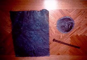
The discovery that our famous “boat” is a red herring would be devastating, except that there have been other finds. The most exciting things are 2 sheets of copper, each about 24” square. One has been crumpled (by ice?) and seems to have tar and oakum or horsehair on one side. The other is still flat and has a faint impression which some think to be a broad arrow on it (RG disagrees). There is also a copper disk, about 6” in diameter has “S8” stamped on it, which may help identification. It appears to be a flattened tin lid. A long (9”) iron spike or bolt (unthreaded, no point) was found as well. All were found in an abandoned Inuit encampment on the height of the northern island.
The helo has been busy today. As well as demobilizing the DGPS site and transferring it to O’Reilly, it has taken JD and Margaret to First Island where they recreate the discovery of the skull for film, and has taken the Icepik to Gjoa for a flight south (his mother in law died). So much for short hops.
Saturday 23 August – At the morning meeting JD has expressed his idea that the ship would have been taken into the “harbour” between the two halves of O’Reilly Island. Yesterday’s depth survey shows that this is possible, the water is deep enough, but I point out that this is inconsistent with the testimony indicating that the ship was far from shore. I also note that any human being would simply describe the location as “between the islands” rather than the involved descriptions we have. JD orders the WIND is told to do a sidescan survey of the “harbour” anyway, while the ERNE will run lines directly to the east of O’Reilly all the way to the south. Margaret is dismayed by the lack of control as to the artifacts which are piling up on the quarterdeck. Rick assures her that everything has been photographed “in situ” and that his notes have enough detail to reconstruct where everything was found. I will sail with the ERNE again today, a party will do a shore search of the remaining shores and will divert to recover my barrel.
The ERNE has an unlucky day. We depart the ship at 09:00 but are forced to return with a faulty generator. We return to the ship to get a spare and don’t start our lines until about 11:00, but manage to complete our depth survey east of O’Reilly and run 3 more to the north before returning to the ship for dinner. We set out again in a rising wind at 17:45 but run out of fuel on one tank and can’t switch over to the other (air lock in line, we have no tools which were landed on the ship this morning as we tried to repair our generator, and forgotten!) The Mark 5 zodiac is dispatched to bring us a wrench but by the time we are running again the weather has become too sloppy and we are forced to return for good.
WIND has surveyed the “harbour” and a small area adjacent, but has found nothing.
RG, Dave G., Margaret and Maxine have taken a zodiac and gone to recover the transom (Dave G landed on O’Reilly to get some shots of caribou). After many adventures they eventually return wet and tired without the transom. RG has to put up with some ribbing about his “35 years experience in small boats.”
Helo is a problem again. Somehow it has discharged the pontoons while sitting on deck and is grounded until new detonators can be obtained (Monday in CamBay). The switch was probably hit in error by Jerry, but he swears up and down that he didn’t, to a disbelieving audience including Kippy. Jerry obviously prefers the ongoing “electrical problems” to “pilot error” as a cause. We are again forced to consider how to demobilize the DGPS station (from O’Reilly this time) and how to transfer our tons of equipment to the airport at CamBay.
Jack Wilson comes into the evening debrief with our photocopy showing the soundings obtained by the ERNE over the last two days. I make another plea for searching to the north end of the box away from shore in compliance with the testimony clues. I don’t think we are in the right place (still like Kirkwall), but if I am wrong I am still sure that the wreck does not lie within a mile of land.
Sunday, 24 August – No morning meeting today. We depart in the ERNE at 08:30, and since we have been given no direction we vote to follow my idea and search the northern end of the box. Unfortunately the weather is not good, the sea is too rough for sidescan. We start doing more hydrography in hopes that the weather will improve, but it never does. We extend the hydrography to the north but the fish never gets wet. Back at the ship at 15:30 in very bad weather. Coming alongside borders on dangerous today and I am very glad to be standing on a solid deck.
WIND spent the whole day drifting in the shelter of the “harbour” waiting for the weather to improve. They never managed any sidescan work either.
Grenier recovered the “transom” today in another zodiac trip. We now have enough of the “yellow” boat to rebuild it.
Interviewed by JD in my cabin. Mostly general topics and praise for the Laurier and her crew. I know the drill and say very nice things about how we have done good and worthwhile work and how I am not disappointed.
Go to ship’s office and write the poem “Franklin 150” for tomorrow. Watch the first full movie of the trip “Rob Roy.” A disappointing day, and only one more chance tomorrow.
Monday, 25 August – Wake up to calm seas. There is again no morning meeting so we are on the water in the ERNE by 07:30. We run N/S lines in the most probable area, WIND is doing the same to the west just E. of the “harbour.” We know we don’t have enough time to finish the area, now we are just hoping for a lucky break. The ERNE can only cover 9 lines (@ 50 yards = 450 yard swath) in 9 hours work since we must be back at the ship by 16:00 to make it back to CamBay for the aircraft tomorrow.
Pat comes out with us in the morning to get some “working” shots. The depths here are much more variable than at Kirkwall, and it is a tiring day of paying out the sonar to 100 yards, then pulling it right in, then paying it out again as we go over the shallows. We arbitrarily cut off our lines at depths of <20m (in the north) or >35m (in an anomalous “hole” in the south). Even so we find nothing, and never join our search area to WIND’s.
On the way back to the ship we are called by WIND who have run aground on a shoal and suffered some damage. A zodiac is en-route to tow them in. They have found nothing either. The damage is severe, thank god it was on the last hour of the last day!
RG led a shore party by boat to the large island in the NE, but nothing was found.
The helo is mysteriously back in service again and the DGPS station is recovered. The floats can’t be recharged, but the flights over water are short enough that the Master and Pilot have agreed to take the risk. With the rising sea it is no picnic on the boats either, and a waterborne recovery was probably not an option either.
Post the poem in the mess when no-one is looking, but the secret is soon out as to who the author is (am I the only literate one?) Packing begins as the ship departs the anchorage and retraces its path out of the area.
We have steak for dinner, and an end-of-expedition party is planned for 19:00. Drinks are on the house but the party is fairly subdued, I think that everyone is now coming to terms with our lack of success and the work that still has to be done to be ready to offload tomorrow.
Tuesday, 26th August – At anchor again in CamBay. Everyone packing furiously. Dave Millar and Dave Kellett come aboard to interview JD and Grenier. They tell us that the NWT flight today is cancelled as the airfield is “too soft” for the aircraft to land. They are unsure of the status of the First Air flight this afternoon, it looks like we might be stranded. The Laurier will be in port until Wednesday afternoon so we have bed for the night if necessary. JD collects tickets and heads ashore to try to make arrangements. Those with connections will be given priority, since I am driving I am not a high priority and expect to be left behind until tomorrow.
People leave the ship by zodiac in dribs and drabs as their seats are confirmed. By lunch there are only 5 of us left aboard, but at the last minute we are told to get our stuff and head ashore. In the end everyone except Margaret gets a seat, and we all scramble on board the turboprop for the long flight south. We miss our connections in Yellowknife, but most make the midnight connection in Edmonton. Margaret will fly to Yellowknife the next day, she wants to go to KWI to look at another site first anyway.
End of expedition.
Franklin 150
Old Franklin lay buried
Seven score and ten
When a team of adventurers
Came searching again
A quite motley crew
Called “Eco-Nova”
Came sailing to Kirkwall
To look the place over
Their home was the Laurier
A snug little nest
Where the Captain and crew
Gave up of their best
“Boatwork at dawn?”
“An afternoon flight?”
“Box lunch for a dozen?”
“We can do that alright!”
Rick and John
(Producers bold)
Had assembled this party
To come to the cold
With phone lines a-buzzing
(and the fax machines too)
Their plans they unfolded
Had to change quite a few
But it all came together
On the dock in CamBay
So they turned their face eastward
And they sailed away.
On the beach at old Kirkwall
Was the DGPS
But the receiver on the ERNE
Was broken I guess
So while WIND ran the sidescan
Old ERNE’s job (still useful)
Was to run the bathymetry
(When she remembered to fuel).
The shore parties clambered
On First Isle and Skinny
Found tent-circles galore
(In fact way too many)
But the wreck remained hidden
Not wholly forgotten
Yet failing to rise from
The flat muddy bottom.
Came a trip to Gjoa Haven
For an aircrew exchange
Then a meeting with Larsen
Was quickly arranged
In the lee of Hat Island
For some fuel and a bite
Then off to O’Reilly
(The second’ry site).
At O’Reilly the beaches
Were littered with wood
And hopes were ignited
That this place was good
But the more we recovered
The less we believed
That the pieces assembled
Were from Terror retrieved.
So this year our trip’s over
And no wreck have we found
But on once empty charts
New soundings abound
And we take satisfaction
From our work and our pain
And we hope with our friends
To come searching again.