Utjulik 2001 Expedition Report
Executive Summary
The Utjulik 2001 expedition was organized to continue the search for the shipwreck, presumably of one of Sir John Franklin’s vessels, HMS EREBUS and TERROR, which had been reported in Inuit testimony as lying somewhere near the west coast of the Adelaide Peninsula (Utjulik). The expedition was conducted under Scientific Research Licence # 0400501R-M issued by the Nunavut Research Institute.
OPERATIONAL PLAN
The search area was defined mainly by the testimony given to Charles Francis Hall (1869) and Frederick Schwatka (1879), supplemented by prior survey work by the Canadian Armed Forces (Project Ootjoolik – 1992) as well as surveys completed in 1997 by the Canadian Coast Guard/Eco Nova (Franklin 150), and by the RCMP vessel Nadon (as part of the 2000 St. Roch II, Voyage of Rediscovery).
The expedition was primarily sponsored with private funds. However, financial and logistical support was gratefully offered by the Vancouver Maritime Museum, the Royal Canadian Geographical Society, Scintrex Ltd., the Canadian Hydrographic Service (CHS), and Harvest Foodworks. In addition, an application for support to the Canadian Forces resulted in the assignment of four Ranger personnel to augment the field team. Details of the expedition team can be found in Appendix 1.
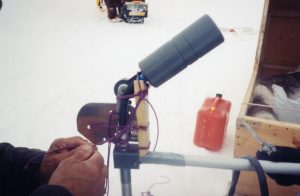
Equipment used in the field survey consisted of the Scintrex Smartmag 4 portable cesium magnetometer and a Knudsen 320A through-ice echo sounder provided by CHS. Field tests using this equipment were conducted on the surface of Lake Simcoe, Ont. in early February 2001 to determine their suitability and operational parameters. It was determined that, with the magnetometer mounted on a sled pulled 10m behind a snowmobile, a 200m line spacing should be adequate to detect the expected signal from a wreck of the reported characteristics of either the EREBUS or TERROR.
IN-FIELD OPERATIONS
The field party spent the period from May 6th to 20th in the Arctic, the survey commencing near Grant Pt on the 9th and finishing on the 16th. The survey completed 477 km of survey line at an average speed of 10 km/hr and covered over 166 km2 of area. This doubled the area coverage of the two prior boat-based surveys (1997 and 2000) combined and demonstrated the efficiency of working over the ice. In addition, 109 soundings were taken at 1000 m intervals as a preliminary reconnaissance survey. Analysis of the data collected is expected to take several months.
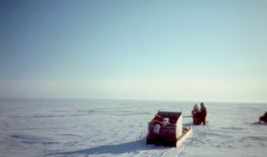
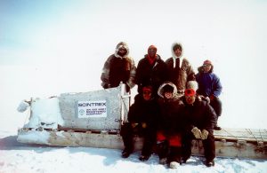
A 4-person field party assembled in Yellowknife NWT on 5 May and flew to Gjoa Haven NT the next day. Here they were met by the four-person Ranger contingent. After an initial briefing, fuel purchase and sled loading, a five-person advance party left Gjoa Haven for a camp on Cape Seaforth on 6 May. The remainder stayed in Gjoa Haven to field-test the survey equipment on Petersen Bay and joined the leading group at Cape Seaforth on 7 May. All personnel then proceeded to a camp on a small island west of Grant Pt. (pos. 68.42 (N) 98.87 (W). Although unnamed on modern charts, this island had been given the working name of “First Island” by the 1997 expedition. During the trip to the area, one of our Rangers informed us that the Inuktitut name for the island was “Umiartalik” – “big boat (or ship) island,” which was very encouraging.
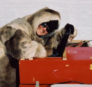
The magnetometer survey consisted of two persons, one snowmobile driver and one magnetometer operator. The SM4 was mounted on a large sled and towed a 10m behind the snowmobile.
Navigation was done using two GPS units (non-differential handhelds), one on a bracket on the snowmobile handlebars and the other in the sled with the magnetometer operator. Selective Availability was off for the period of this survey. Tracks were recorded from each GPS, and the data was downloaded from the magnetometer console onto laptops after every run, and multiple backups were made.
The survey areas were run on east-west lines of various lengths between preplanned waypoints as the ice conditions would allow. A 200 m spacing of lines was usually possible, although there were occasions when this was exceeded. As the lines became longer and further from the base camp, and with the appearance of sizeable thinly-covered seal breathing holes in decreasing ice thickness, it was decided to send out a second snowmobile and driver as a safety measure. If the lead scouting driver navigated the line, the sled-pulling machine could easily follow in their tracks. This increased the workload but significantly improved navigational accuracy.
The echo-sounding party consisted of four persons manning two snowmobiles and sleds. The first two would navigate to the preplanned sounding location and clear the surface snow to the sea ice. The second sled would then come up to that position and set up the Knudson 320A transducer on the ice and take and record the sounding. While doing this, the first party would search for the following location. Using this methodology, it was possible to do soundings 1000 m apart at 5-7 minute intervals. This work was reduced after attaining the promised 100 soundings to free up a snowmobile and personnel for the magnetic survey.
Results
The survey was conducted from camp from approximately midnight of May 8th until midnight of May 16th. However, equipment problems prevented any survey on May 15th and allowed only a few hours the following day. The party returned from Umiartalik Island to Gjoa Haven on the 17th-18th of May, stopping overnight on the 17th at Cape Seaforth.
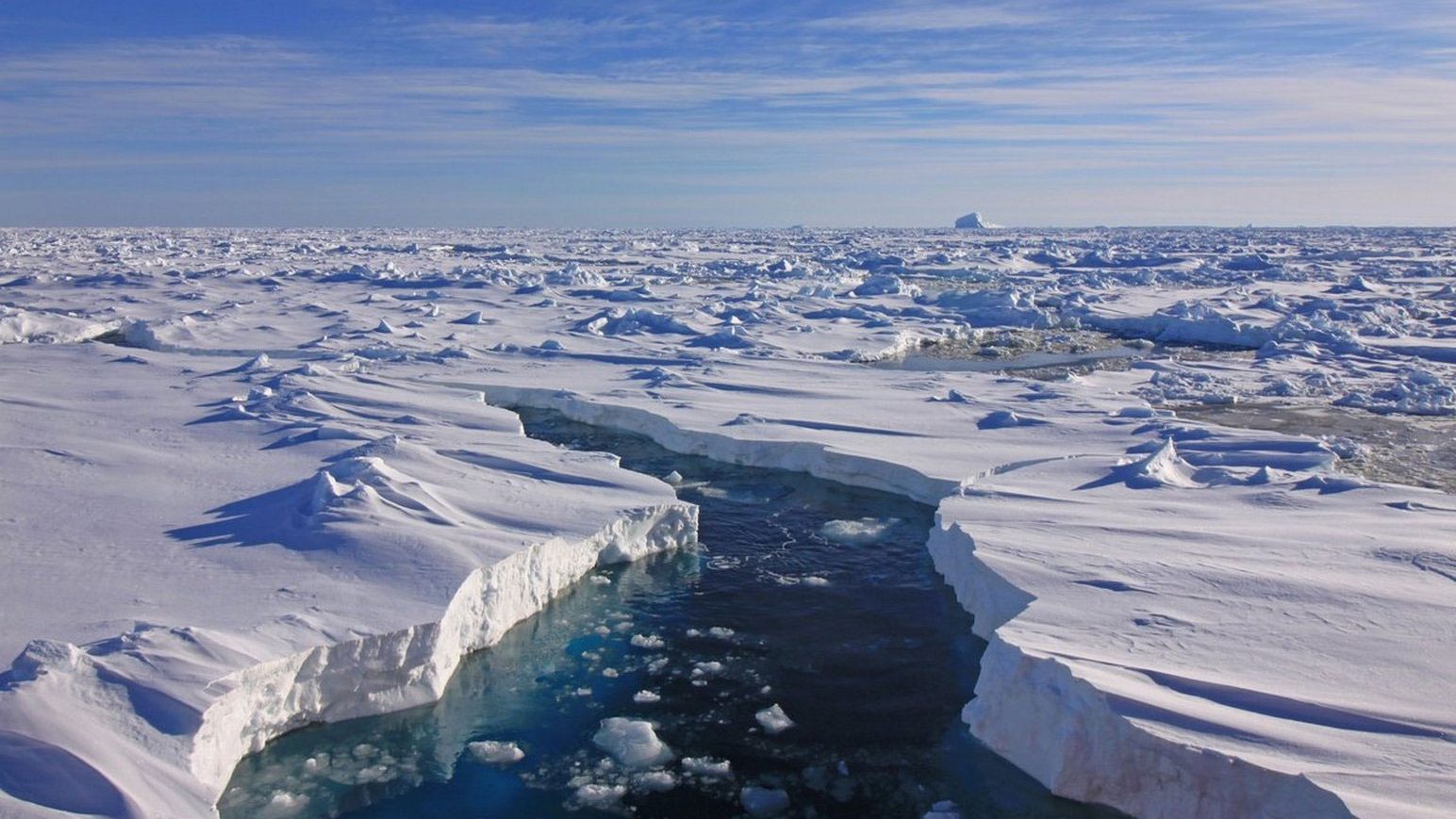
The weather was generally favourable throughout the fieldwork, although severe storms bracketed the party’s time in the field. Temperatures ranged from -10 to -30C, and the winds ranged from calm to 35 knots, coming from every direction at some time. Approximately 1 meter of snow fell on the camp once, and there was light rain on the return to Gjoa Haven. Ice conditions were generally good for first-year ice, with sastrugi and some areas of broken ice, which appeared to correlate with shallower regions. It was usually possible to maintain the desired line despite ice conditions. The expedition was initially planned for mid-April to mid-May to take advantage of generally better weather and ice conditions; this should still be considered for future work. Near the end of our fieldwork, warmer temperatures caused heavy surface snow, frequent large open seal breathing holes, and evidence of water upwelling through cracks in the ice. Whiteout conditions were common, especially in the early morning hours.
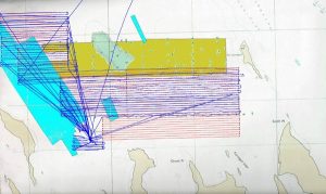
The survey completed 477 km of surveyed line, covered over 166 km2 of area, and obtained 109 soundings. The remaining unsurveyed area of the planned northern survey is 22 km2. Most of this area was covered by the echo-sounding party and found to be consistently shallower than 20m, and it can probably be eliminated as a likely spot for the wreck. It is felt that the area was covered with sufficient accuracy to preclude “missing” a target with the wreck’s expected characteristics. All magnetometer data is being analyzed with a scheduled completion date of September 2001. All sounding data has been turned over to the Canadian Hydrographic Service.
LESSONS LEARNED
1. Although the weather was highly cooperative in 2001, it is still felt that the period from mid-April to mid-May would be preferable for this type of survey due to colder temperatures and better ice/snow conditions.
2. The large solar panels used for the hydrographic batteries were insufficient to keep the batteries fully charged, delivering only a trickle charge on bright days. A portable generator is essential.
3. All electronics and batteries must be kept warm for use in the field. Various methods were employed – chemical hand warmers, charcoal hand warmers, and water bottles. The latter proved the most effective but unavailable commercially in Nunavut.
4. The support of the Ranger contingent was essential in conducting the survey. Locally experienced people can advise on ice conditions and travelling methods and provide invaluable counsel on operating procedures.
5. Through-ice surveys were shown to offer the greatest potential coverage in the least time and to be the most cost-effective way of gathering magnetometer and sounding data in this area of the Arctic.
Appendix 1: Utjulik 2001 Team
Mr. Jim Delgado – Archaeologist and VMM Liason
Mr. George Hobson – RCGS Liason
Mr. Brad Nelson – Magnetometer data analysis
Mr. Andrew Leyzack – Hydrographer and CHS Liason
Field party:
Ranger Saul Aksalook
Ms. Amie Gibbins
Mr. Tom Gross
Mcpl Simon Hiqiniq
Ranger Charlie Ikkutisluk
Mr. Bill Robinson
Cpl. Doug Stern
Mr. Dave Woodman