The Back of Beyond – 1994 Expedition
As Ian banked the Twin Otter over the aquamarine melt pools of Collinson Inlet I thought of my boots. Fourteen years ago I had bought them in anticipation of setting out on a search of King William Island for the buried records of the lost Franklin Expedition. In 1980, with the arrogant optimism of youth, I had believed that search to be relatively easy and only a few months away – a year at the most. Now, as the familiar landmarks passed by below, my boots were about to justify their cost.
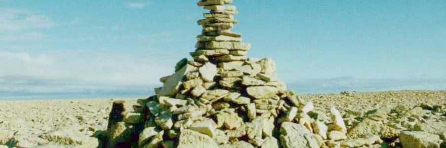
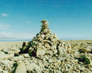 As we circled Cape Jane Franklin looking for an appropriate landing spot the enormity of the task which had been set for our team struck me. Only one man-made feature existed on that barren landscape of soggy tundra and raised gravel beaches, an eleven-foot Innookshoo (cairn) which dominated the central hill. We would soon become very adept at using this solitary marker to set our course, and familiar with the boot-shredding broken limestone used in its construction.
Our ten-person party had been lured to this desolate coast by the call of the most enduring mystery of nineteenth-century Arctic exploration, the loss of the Franklin expedition of 1845. We knew that on 25 April 1848 one hundred and five crewmen landed here after abandoning their ships fifteen miles offshore. Those vessels, HMS EREBUS and HMS TERROR, had been locked in the pack ice of Victoria Strait since September 1846. After three years of struggle their efforts to find the last link in the elusive Northwest Passage had been rewarded, but the stubborn ice refused to let them sail through it. Thoughts had turned from glorious exploration to simple survival.
This information came from a short note which was deposited in a nearby cairn. It informed the world that “Sir John Franklin died on the 11th June 1847,” that “the total loss by deaths in the Expedition has been to this date 9 officers & 15 men,” and that the remainder, now under the command of Captain Francis Crozier, would “start on tomorrow 26th for Back’s Fish River.” None of Crozier’s men survived.
Analysts have been long puzzled by the ad hoc nature of Crozier’s last record. Hastily scribbled around the margin of a previously-used form, the disjointed note seems to have been done on the spur of the moment. Found by McClintock in 1859, he noted that “no log-book could be more provokingly laconic. Yet that ANY RECORD AT ALL should be deposited after the abandonment of the ships, does not seem to have been intended.”
More than one historian had surmised that the surviving record which has reached us is no more than a postscript, and that Crozier felt no need for elaboration since he had caused the expedition’s full records to be deposited in a well-marked position nearby. Since the passage of Franklin’s men the entire twenty-mile stretch of coast from Cape Felix to Cape Jane Franklin had been repeatedly searched for traces of records without success. A whole series of cairns had been found along this coast which may have originally been intended as signposts, one at Cape Felix was found shielding a piece of paper on which was tantalizingly drawn a picture of a hand with a pointing finger! What was needed was another clue to narrow down the search area.
We believed that we had that clue in the reminiscences of the native hunter Supunger. Interviewed by the American explorer Hall in 1866, Supunger remarked that in 1862 he and his uncle had visited northwestern King William Island. Having heard of McClintock’s journey three years earlier, “their object was to search for things that once belonged to the white men who had died.” Fourteen winters had not yet completely removed traces of Franklin’s men – between Cape Felix and Collinson Inlet the two hunters found a canvas “tupik” (tent). Supunger told that “a little way inland” he found the skeleton of a “Kobluna” (white man), and that “near this skeleton they saw a stick standing erect wh. had been broken off – the part broken off lying close by.” Even more intriguing was what had been found near the “stick.”
What attracted their attention the most on arriving at this pillar was a stone – or rather several large flat stones lying flat on the sandy ground & tight to-gether. After much labor one of these stones was loosened from its carefully fixed position & by great exertions of both nephew & uncle the stone was lifted up a little at one edge just sufficient that they could see that another tier of large flat stones firmly & tightly fitted together was underneath. This discouraged them in their purpose wh. was to remove the stones to see what had been buried there for they was [sic] quite sure that something valuable was underneath.
When Supunger marked out the size of this layer of flat stones on the snow Hall noted that it measured 4 feet by 2 feet. Both Hall and his interpreter Tookoolitoo were very excited by Supunger’s description of the layer of carefully prepared stones which had been placed “so as to make it impossible for any water to get between them.” When Supunger paused in his story Tookoolitoo turned to Hall “with a joyful face” and said, “I guess I can tell just what that is for – for papers!” Hall agreed, noting that “time & again Su-pung-er said that the stones were just as if they were tied together. My conclusions are that the stones were laid in cement & that they cover a vault of the precious Documents of the Franklin Expedition.”
According to Supunger he and his uncle also found “many graves of the Kob-lu-nas not far from the place just described,” including one which was “of the depth from the feet up to the navel & of a length more than a man’s height & wider than the width of a man’s shoulders.” This grave “was all nicely walled with flat stones placed on or above another, flatwise” and in it they found a clasp knife, a human leg bone and a skull. Many commentators believed that such an elaborate grave could only have been built for Sir John himself.
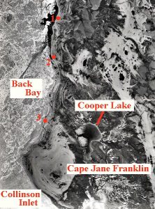
Of course Supunger’s story had been repeatedly checked out in the intervening century. Searches conducted by Schwatka (1879), Burwash (1930), Cooper (1954-5), the Canadian Armed Forces (1967), and Beattie (1982) had all investigated the area near Crozier’s Landing without success. Yet each had made use of an edited version of Supunger’s story which had been published in 1879, we believed that none of these search parties had utilized the best clues – those contained in Hall’s unpublished fieldnotes. While reading through these in May of 1993 I found that those detailed notes of Hall’s interviews with Supunger pointed to a very specific area, described as “close by the coast above Back’s Bay, not far from Victory Point as Su-pung-er has shown on the chart.” Modern charts show Back Bay encompassing the entire coast from Victory to Franklin Points, and as it is uncertain what chart Hall was using this provided only a general clue.
There seemed to be other clues in Supunger’s evidence. McClintock found a pile of clothing four feet high at Crozier’s Landing in 1859, three years later Supunger and his uncle had discovered “a great pile of clothing further N. on King Williams Land than the graves.” Furthermore, Supunger noted that near the tent he had found a “curiosity,” a large iron thing which “had on one side or end a great many small pieces of iron close enough together to make it look something like spears – fish spears.” Hall concluded that “these pieces of iron can be none other than a grate in the stove for burning hard coal.” The presence of the clothing and a heavy cook stove near the tent seemed to confirm that Supunger was talking about Crozier’s 1848 campsite – McClintock noted “four heavy sets of boat’s cooking stoves” there.
As Supunger noted that the graves were found to the south of the pile of clothing, and that “the large tent seen, & the flat stones covering something” were “above that is N. of the big or long bay” (which we assumed to be Collinson Inlet), we effectively reduced the search area to about five miles of coastline around Cape Jane Franklin. The last clue seemed to lie in Supunger’s description of the site itself. The post had been “deeply set in the sand” and waterborne sand had partially filled the deep grave. We were looking for a sandy spot probably to the south of, and inland from, Crozier’s Landing.
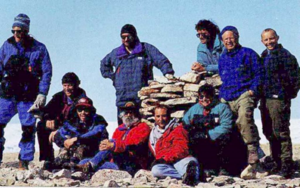
With these clues in hand I approached Dr. George Hobson for advice on obtaining official permission for a small-scale search but I was soon overwhelmed by his expertise, gained from a lifetime of arctic work, and his enthusiasm. In short order George had approached the Royal Canadian Geographical Society (of which he is a past director {check}) and PROJECT SUPUNGER was born. A diverse but highly experienced team was assembled from all over the country {see sidebar} and, after months of seemingly interminable legal and logistical preparation, we were ready to put our theories to the test.
Our archaeological permit allowed us to conduct a surface search between Crozier’s Landing and Collinson Inlet as far inland as Cooper Lake, an area of about nine square miles. Mindful that what we searched for was essentially subterranean, and that Supunger had removed the only marker (the post) one hundred and thirty two years earlier, I calculated that a party of ten at twenty foot spacing would require at least ten days to conduct a thorough search. Factoring in a few days for bad weather we settled on twelve days, 120 man-days, which would almost double the effort that had been expended in the area in the last century.
In addition we were bringing Ground Penetrating Radar to the site in the hope that we could unobtrusively investigate any appropriate surface finds, all of which would be mapped using our three handheld Global Positioning System (GPS) units. Although every previous party had claimed to have left no stone unturned each had been subsequently embarrassed by future searchers, we would endeavour to avoid that fate.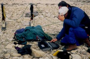
Armed with Supunger’s testimony, a large aerial photo, and information provided by Cambridge Bay residents Tom Gross and Joanne Laserich (who had briefly visited the area only the month before), we all craned our necks out of the aircraft windows looking for some large flat rocks set in a sandy area. Only when standing on the flat windswept top of the esker at Cape Jane Franklin did reality set in. The landscape was covered with large flat slabs of limestone suitable for Supunger’s structures, but the surface primarily consisted of unstable smaller broken pieces thrust up at oblique angles. Most of our nine-square mile area was not only inconsistent with Supunger’s description, but would have totally unsuitable for Crozier’s excavators.
After a few days of search it became apparent that our actual search area would be much smaller. By modifying “sand” to “gravel,” and liberally interpreting that to mean “capable of being excavated,” we found that only the raised beaches immediately inland from Crozier’s Landing offered any reasonable hope of success. Since Supunger’s description indicated that this was our highest-priority search area this was not totally unwelcome news, and we confidently expected that a few days search would put the matter to rest.
The first job after disembarkation was obvious. Standing in the strong wind of the landing area on top of the hill it was quickly decided to move our mountain of gear to a lower level which we hoped would offer shelter. As it turned out we chanced on the best campsite in the entire search area, relatively flat and dry, and close to water. Although the wind was everpresent it was too inconsistent in direction for our camp to be totally secure, at one time it flattened two tents (destroying one). Nevertheless, we were never tempted to relocate to any other area of that inhospitable shore.
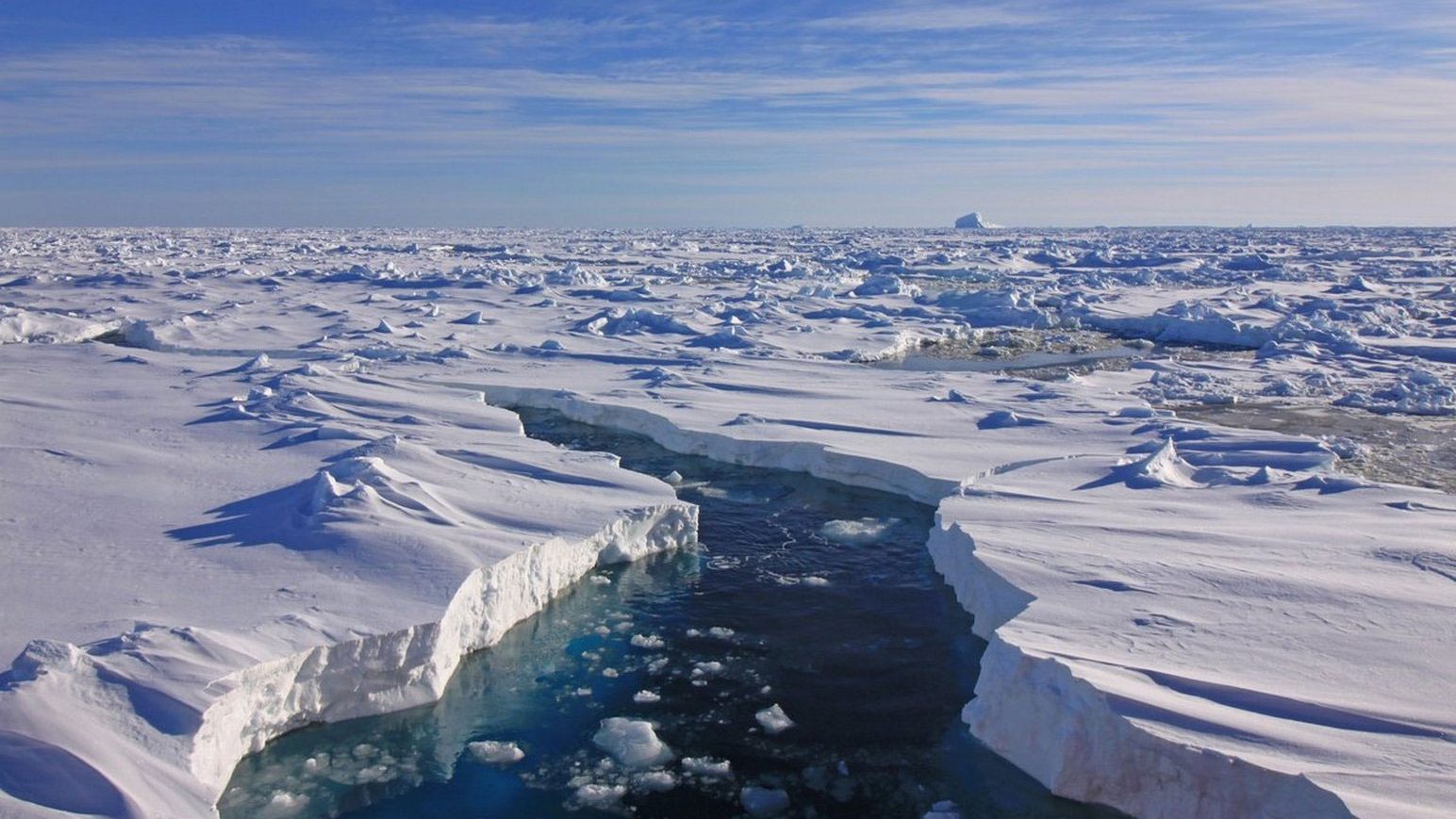
Supunger City, consisting of o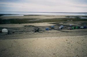 ur ten personal tents and one large cooktent, instantly became the second-largest “town” on King William Island, and if the amenities and opportunities of entertainment were meagre, the view of Collinson Inlet was spectacular. The physical desolation of northwest King William Island, which featured prominently in every account written of the area, was difficult to appreciate until one stood there. It was easy to understand why even the Inuit called this area Tununeq – “the back of beyond.” Among our team were seasoned arctic veterans who had visited most of the islands in the archipelago, yet their unanimous opinion was that Franklin’s men had been cast upon the most unforgiving and inhospitable terrain they had ever seen – and we were seeing it at the height of the short summer!
Throughout our stay we saw very little wildlife, a few seal out on the ice, one distant Musk-ox, seven caribou, one fox, and a few dozen geese, ptarmigan and ducks. Supunger had also noted that on this windswept coast “game was very scarce & for this reason could not prolong their search along down the W. side of the Island as far as they desired.” The nine char caught in Cooper Lake were a welcome change from our reconstituted meals, but there was no possibility that even our relatively small party could have “lived off the land.” Crozier’s hundred men, travelling in April, would have faced an even bleaker prospect.
In one regard Crozier’s marchers did have one advantage – one which goes a long way to explaining their decision to abandon the ships so early in the season. From their previous shore parties they must have known that travel on the island became immensely more difficult once the snowcover melted. A few days of walking on ankle-turning uneven limestone slabs, many set edgewise in unstable “oyster beds,” began to wear down even the toughest Vibram soles. The shore ice and snowcovered gravel beaches of April would have provided much better conditions for travel than the bare rock of July.
 We began finding traces of human activity almost immediately. Some, like the remains of a large freight canoe found on the Collinson Inlet shore, were intriguing. Others, garbage from past expeditions, abandoned oil drums and flotsam on the shore, were dismaying. Each discovery, from an old cigarette package or rusty wrench to a can of bright orange spray paint under a rock, testified to the thoroughness of our search. Every broken down cairn and cache of stone (20), every tent circle (22), every piece of fragmentary bone (177) or fragment of worked wood, was scrutinized for clues.
In each possible area we walked in line abreast, repeatedly covering the same ground in overlapping sweeps. We quickly became adept at finding bones, usually covered in lichen by the neverending cycle of life, and we learned how to differentiate skeletal remains of bear, caribou, and seal (the flipper bones of which are uncannily like those of a human foot). At each promising find the line would temporarily stop while Walt Kowal and his “bone book” sprang into action.
On the evening of the second day we came across our first human remains by accident. After a full day of search our resident fishermen set off to try their luck, while some others of us went off to the area’s most prominent landmark – the large Innookshoo on the west side of Cape Jane Franklin. We had been told of a bone to the south of this marker, found the month before by Tom and Joanne, which they thought might be part of a human humerus. After a half-hour search we found the bone (it was a seal) and considering the difficulty which this had presented, using the month-old testimony of eyewitnesses, I was beginning to wonder whether Supunger’s translated tale would be sufficient to lead us to his site. While lounging at the cairn we heard a rifle shot and saw one of the fishermen waving to us from the north side of the hill.
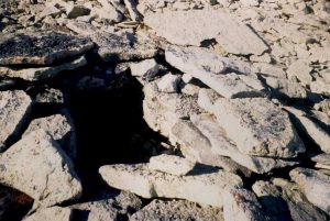
Having had no luck at their sport the sportsmen had decided to do some impromptu searching. On our arrival we found Bill Mooney standing over an obvious grave on the hill’s northern crest. Hunting implements found on the surface nearby convinced us that it was that of a native hunter. More fascinating yet was the discovery of a heavily weathered human skull at the base of the hill and five depositories excavated in the hillside, one of which contained a human tibia. Despite our initial excitement it was highly unlikely that these were the remains of one of Franklin’s men. The presence of the hunting implements nearby was suggestive, while the location seemed too far inland. The description did not tie in with Supunger’s tale and there was, as usual, no sandy place suitable for digging.
Nevertheless we spent the next day thoroughly combing the immediate area, uncovering nothing more dramatic than a few tent circles and the embers of an old fire. A week later, while Walt was doing his detailed measurement of the skull and taking small bone samples for analysis at a southern lab, he came across the lower jaw and four more teeth nearby. That we had initially missed these forcefully demonstrated that even the most thorough search could not be considered entirely comprehensive. Chemical analysis of the bone samples confirmed that it belonged to an Inuk male between 25 and 40 years of age.
As we worked our way from this place toward the coast we began to come upon more numerous tent circles and caches. Two of these latter structures were of a different character than all the rest, regularly and carefully built rectangular repositories built up of carefully chosen stones. Opinions about these varied. Although only three to four feet long some felt that it would have been possible to deposit a body in these, others felt that the proportions would have been appropriate to wooden chests, while others maintained that they had seen Inuit meat caches elsewhere in the arctic built with equal care (although no others in our area). Whatever their source these constructions were obviously not the excavations spoken of by Supunger, and a very thorough search of the vicinity failed to produce any evidence that they were made by Franklin’s crews.
Another interesting feature was a frost boil, about six feet in diameter. There were many of these, but one in particular looked promising as it had obviously been excavated at some point. It seemed to be a reasonable target for our Ground Penetrating Radar. Analysis of the radar results indicated an “anomaly” about two meters down, prompting us to dig the next day. However it quickly became apparent that we were digging through undisturbed deposits, and nothing was found.
The lack of detailed reports by previous searchers left us in doubt as to the origin of many of the features we found. The age of a cairn can be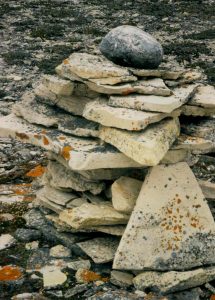 roughly determined by the amount of lichen which forms on the rocks, especially in the interstices, but even an apparently recent cairn can be the result of reconstruction. Walt Kowal, who alone had previously visited the site (with Beattie in 1982) informed us that his party had restored the top of the large Inookshoo, although the base was of unknown age. Another cairn near Cooper Lake was probably built or rebuilt by Burwash or Cooper, although it too may have originally marked the midpoint of a trail through the “valley” of the Cooper River for Franklin’s men.
Even the origin of the cairn at Crozier’s Landing is now uncertain. Is it built over the original or is that now reduced to one of the indescript low piles of rock nearby? Similar questions surround the excavation nearby, thought to have been done at the site of the only grave found at the Landing (usually attributed to Lieutenant Irving) by Burwash. Of another excavation which Schwatka reported having dug for twenty feet north of the original cairn there is no evidence. One of the purposes of our expedition was to accurately map all the features of this historic coastline using GPS to finally establish a known baseline from which future investigators could work.
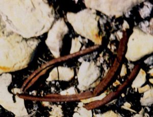
The only certain Franklin expedition relics all came from the landing place itself. Here small pieces of tin, glass, canvas and wood still mark the 1848 encampment. A small sample of the rim of a tin canister was taken so that adhering solder could be analysed in the light of Dr. Beattie’s lead-poisoning work. The only personal item found was a rusty belt buckle, while a beautiful hand-sewn grommet in a piece of canvas testified to the meticulous seamanship of an earlier age.
Further north, on Victory Point, we found the remains of two cairns. One, obviously recent, was found on the beach near some very fresh aircraft tracks. The other, as indicated by a commemorative marker, had once contained an emergency pack. The pack had been removed, and garbage lying about led us to believe it had been pillaged rather than used for its intended purpose.
As areas were eliminated by days of often tedious search we came to the reluctant conclusion that Supunger’s structures, if here at all, were now hidden from human view. The evidence which had seemed so strong in the south was now taken apart bit by bit. Synonyms were sought for each translated word or phrase – the site was “back” from the camp (interpreted by Hall as “inland” could it have meant “north” – “back” in the direction from which Supunger had come?) The “big bay” to the south of the site had seemed an obvious reference to Collinson Inlet, but Hall had called it Back Bay, did it actually refer to modern Back Bay or even Wall Bay further north? Had the pile of clothes been found at another campsite? Even the stoves were problematical, Supunger spoke of one, McClintock and Schwatka four. Selective reinterpretation made any of these scenarios possible – unfortunately we had time, permission and resources to investigate only the most probable.
Schwatka, the first to investigate Hall’s report of a vault had stated that “a short sojourn in these parts soon destroyed all my faith in such an hypothesis.” The 1967 team of five servicemen who had spent ten days in detailed search for Franklin’s grave had concluded that “if it had been there we would have found it.” Although unwilling to embrace either Schwatka’s pessimism or the soldier’s certitude, our own search was comprehensive enough to demonstrate that Supunger’s vaults probably lie elsewhere. Although disappointed in having no concrete result, this in itself is evidence in the long reconstruction of the events surrounding this pivotal event in Canadian history. Honest effort in a good cause is never wasted and there is no shame in failing to find what you seek, only in failing to seek.
As we broke camp in preparation for the aircraft home every team member could agree that we had had a memorable experience. Memories of the wind, chilling mist, and long days walking over difficult terrain would soon fade, while those of camaraderie, laughter, and shared anticipation and excitement at each new discovery would remain. We emerged safe and healthy, and, unlike Franklin’s poor men, would be reunited with our loved ones in two days.
Rest, showers, and a quick trip to the junk food counter would alleviate our worst complaints, but my poor boots would never be the same. Worn down and repeatedly pierced by sharp rocks they had offered only scant protection for the last week. I briefly considered burying them on King William Island as a fitting memorial of my visit, but could not reconcile that with my insistence on a “no trace” campsite. As the Twin Otter lifted us away over the ice of Victoria Strait they nestled in the bottom of my pack, worn down from the experience but having fulfilled their destiny. That was fitting too.