Supunger’s Travels
There are many questions that arise in any discussion of the stories of the Inuk hunter Supunger (of various spellings) recorded by Charles Francis Hall. Hall’s excitement over learning of “vaults,” potentially containing the grave of a senior officer (presumed to be Franklin himself) and valuable expedition records, has hardly abated and served as the impetus for expeditions from Schwatka (1879) to Tom Gross (ongoing). Any treatment of these stories must first determine the appropriate geographical area of Supunger’s search.
One would think that this issue would be easily settled. As with many aspects of Inuit testimony and the Franklin story, this is not the case.
Two interviews conducted by Hall during 1866 seem to bear on this problem. In both cases, the informants were Arvilingmiut, originally from Pelly Bay, who told Hall of visits to King William Island. The first occurred on May 4th:
“This morning 2 of the men of Pelly Bay told me how about 2 years ago they went from Pelly Bay to Kee-ik-tung King Williams Land but stopped on the island only a short time. Went direct from upper part of Pelly Bay over land to Spence Bay + once across the ice to King Williams Land passing S. Point of Matty Island – thence on Wellington Channel – thence NW on the ice sealing. These Innuits pointed out on Rae’s Chart exactly the course they took in going out + returning wh. was the same … Su-pung-er who has been to King Williams Land + knows just where the Sealed Record Vault (as I think it is) really lies.” (Field Note Book May 3 to 7 {1866} – Friday May 4th 1866)
This itinerary is straightforward and logical, followed by Rae and J.C. Ross in their earlier approaches to King William Island. It followed the traditional route and was undoubtedly suggested by Inuit to these explorers before and during their travels. It should be noted that Hall doesn’t specifically name the “2 of the men of Pelly Bay.” Supunger was one of the Pelly Bay Inuit in camp with Hall at the time, but the concluding mention of him is an awkward final, unconnected note in the field note of the day.
Confusingly, when Hall interviewed Supunger himself that day, he gave a different description of his travels:
“Friday, May 4th, 1866 … some four years ago one of the men of the Pelly Bay natives in whose village we are encamped, whose name is Su-pung-er, visited Kee-it-tung (King Williams Land) & passes from one end (the south end) to the other (the N. end) in summer when the snow was entirely off the ground. He was accompanied by his father’s brother. Their object was to search for things that once belonged to the white men who had died on & in the neighborhood of King William’s Land … Last evening at a late hour this native was in my Igloo where I took up Dr Rae’s chart & by the aid of Nuk-er-zhoo, Su-pung-er told me of this journey & some of its incidents.” Hall Collection, JOURNAL, MAY 1866-JULY 14, 1866 – 58919-N (#11)
The two tales are superficially similar – of two Inuit visits, each with two participants, to the same island. However, the differences between these two accounts are stark. One occurred “two years ago,” the other four. One was motivated by a hunt for seals, the other “to search for things that once belonged to the white men.” One route was east-to-west, the other north-to-south.
Two months later, Hall interviewed Supunger again. This time his route was laid out in impressive detail:
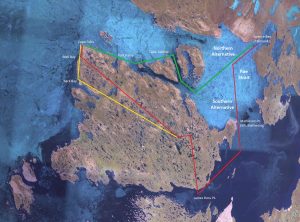
“Su-pung-er take a pencil at my request + marks on the map the track made by himself +uncle from Neikeh-il-lee to King Williams Land. The large Admiralty Arctic Chart before us is substituted by Ross’ at Su-pung-er’s desire for the latter is more distinct for him having what represent water colored blue. He marks his outward + homeward tracks. From Spence bay he + uncle progress Westward and Southward till half way to King William Land, the[n] turn due south passing through Rae Strait down the middle of it + (last) after doubling the point of land called by Rae “Matheson Island” go S.W. to Pt. Booth + thence along the ice (wh. was the element on wh. they traveled from Neitch-il-lee) westward to Pt. Jes. Ross “whence they passed onto K.W. Land. Then the tracks run due N. Till near the 69th parallel when it turns W. for 10 or 15 miles. There a stop was made, indicated on the chart or map by having penciling. However the track up almost N.N.W. through the middle of the Island to Wall Bay + thence along the coast to Cape Felix. Thence the track runs along down along the N.W. side of King William Land to Back’s Bay + thence to the place where the stop had been mark in the outward journey. Near there they met with Neich-il-lee Innuits. Thence the track was due S. striking the co[a]st south end of K.W.I. a little E. of Peffer River + from thence returned the way they had come from Neitch-il-lee except passing over the base of the point of land called Matheson Island by Rae.” (Hall Collection, Journal 58919-N (#11) – interview conducted 14 July 1866)
 It would seem that this well-described route would solve the issue. But what should we make of the alternative east-west route? The answer is buried in a detail of Supunger’s May 4th later description of what he actually found on his travels:
“[P]revious to starting on this journey [emphasis added] they saw a big pile of clothing at Cape Sabine N the head of Wellington Strait … See-pung-er, three years before, had visited King William’s Land. He told Hall that he had seen, “near Shar-too … a very high and singular E-nook-shoo-yer (monument), built by kob-lu-nas, of stones, and having at its top a piece of wood something like a hand pointing in a certain direction. He had also seen a monument about the height of a tall man, at another point somewhere between Port Parry and Cape Sabine.”
A quick look at the chart shows that Cape Sabine and Port Parry lie on the east-west route previously mentioned. The inconsistency of dates, ranging from two to four years previously, is interesting, but there can be little doubt that Supunger made two trips to King William Island. The first was a sealing excursion, on which he travelled the efficient traditional east-west route. On that first trip he was surprised to discover a pile of white men’s clothing and a monument with a pointing hand. The next year, or perhaps two years later, he and his uncle decided to search more comprehensively for the Franklin crews’ abandoned treasures. Having heard from other Inuit that these were to be found along the south coast of King William Island, and more recently from the natives who had welcomed McClintock back from his 1859 travels that more was to be found on the northwest shore, he and his uncle planned a visit that would comprehensively encompass both areas.
This is significant because we can confidently place Supunger’s interesting findings in a geographical context. Everything described by him must be searched for to the northeast of a line running from James Ross Point in the south to Cape Sir John Franklin on the west coast. Supunger’s seemingly contradictory accounts about his travels actually demonstrate that he had a very accurate knowledge of the geography of King William Island, from the northern point (Cape Felix) to the big bay (Collinson Inlet), and the southern coast and off-lying islands to the east. Failing strong counter evidence, we should trust his identification of the places where he encountered the explorer’s camps and detritus.