The Most Fatiguing Journey: Rae up the coast of Melville Peninsula
Rae and Corrigal at Fraser Bay [sp?] 22 May 1847 (68° 33’N, 85° 20’W)
We had not advanced many miles farther, when some deer were noticed at no great distance, feeding on the banks of a stream. Being desirous of procuring some venison if possible, I sent Corrigal (who, with other good qualities, was a very fair shot) after them, and he was fortunate enough to shoot a fine buck. But the buck, though wounded, could still run too fast to be overtaken, and the sportsman was just about to give up the chase when I joined him, and we continued the pursuit together. {p 149}
Rae helpfully described Garry Bay as “the most strangely shaped” one of his acquaintance presenting “three long, narrow, and high points of land” with “four inlets” the most southernmost which he named for Lieutenant Halkett (inventor of the inflatable “Halkett Boat” – a precursor to the modern rubber dingy), and the most northerly one for Mr. Black.
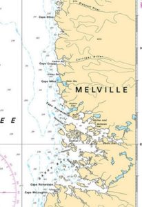
Rae obtained a noon sight and derived a latitude of 68° 59′ 15″ N. The next night the party proceeded to Cape Miles, and obtained a latitude of 69° 19′ 39″ by “a good meridian observation of the sun.”
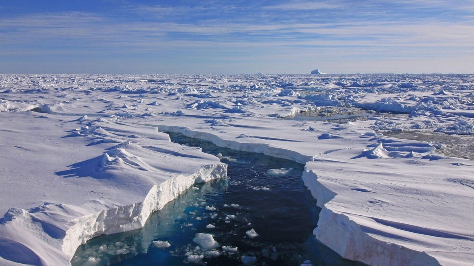
Our provisions being now nearly all used, I could advance only half a night’s journey further to the northward, and return the following morning to our present quarters. Leaving one of the men, I set out with the other at half-past 9 P.M., the snow falling fast; and although we had little or nothing to carry, the travelling was very fatiguing as we crossed Baker Bay – so named in memory of a much valued friend – at the north side of which we arrived after a walk of four miles. It now snowed so thick that we could not see farther than fifty yards around us, and we were consequently obliged to follow the windings of the shore, which, when we had traced it six miles beyond Baker Bay, turned sharp to the eastward; but the weather continuing thick, I could not see how far it preserved this trending.
After waiting here nearly an hour, the sky cleared up for a few minutes at 4 A.M., which enabled me to discover that we were on the south shore of a considerable bay, and I could also obtain a distinct view of the coast line for nearly twelve miles beyond it.
To the most distant visible point (latitude 69° 42′ N, longitude 85° 8′ W) I gave the name of Cape Ellice, after Edward Ellice, Esq. M.P., one of the Directors of the Company; the bay to the northward, and the headland on which we stood, were respectively named after the distinguished navigators Sir Edward Parry and Captain Crozier.
Finding it hopeless to attempt reaching the strait of the Fury and Hecla, from which Cape Ellice could not be more than ten miles distant, we took possession of our discoveries with the usual formalities, and retraced our steps, arriving at our encampment of the previous day at half-past 8 A.M.
Our journey towards the strait of the Fury and Hecla was commenced on the 13th May. My companions were 4 picked men and Ouligbuck. [note in “Narrative” p 137-8 “… Corrigal (our snow house builder), Folster, Matheson, and Mineau, with Ouligbuck as deer-hunter and interpreter.”] A fatigue party of 2 men and an Esquimaux, with a dog sled accompanied us for 3 days. With these I sent back Ouligbuck who was unable to walk so fast as was desirable. Each of the party was laden with 60 or 70 Lbs. My own load was only about 40 Lbs. but as I led the way this trifling weight was quite enough. {Rich 41}
Although not very stout when I set out, I had to tighten my belt six inches before my return.{Rich 41}
[According to “Narrative” p 6, and Rich p 47, John Corrigal and John Folster were Orkneymen, Hilard Mineau was a “Canadian”, and Peter Matheson was a Highlander.]
As the dogs were of little use during the last journey, I took none with me now. {Rich 62, letter to Simpson and Committee, 21 Sept 1847}
Two blankets and as many hairy deer skins constituted the bedding of the party.{Rich 62}
Rich [Rae.correspondence] [63]
On the 20th we were detained twenty four hours by stormy weather at Cape Lady Simpson, a long point in Latitude 68°-10′-N Longitude 85°-53′ West. We rounded Selkirk Bay (called after the noble Earl of that name) on the 21st and after passing a number of small points and Bays we encamped on what at first appeared to be a part of the mainland but which was afterwards found to be an Island. Our snow house on the 25th was built in Latitude 68°-48′ north, Longde. 85°-4′ W. near a small stream frozen (- like all others we had passed -) to the bottom. We had not yet obtained a drop of water of nature’s thawing, and fuel being rather a scarce article, we sometimes took small kettles of snow under the blanket with us, to thaw it by the heat of our bodies.
Leaving two men to endeavour to fish and shoot I went forward with the others and crossed Garry Bay passing inside a number of Islets which by breaking the force of the ice from seaward, had given us much better walking than I could have anticipated. We passed the day on an Island near the north side of the Bay, some bear tracks and a flock of Long-tailed ducks were seen.
Our course on the following night lay to the westward
[64]
of north, the coast being high and rocky, and indented with numerous Inlets. After accomplishing twenty miles in a straight line we encamped; as the weather looked fine we did not build our usual comfortable lodgings which I had afterwards cause to regret, as a heavy fall of snow soon came on. We were now in Latitude 69°-19′-39″ N and Longitude 85°-4′ W. The latter is evidently erroneous, as I had neither Chronometer nor watch that I could place dependence upon, and the Compasses were much affected by local attraction.
Our provisions being nearly done, I could only proceed half a days journey further Northward and return the same night to our present quarters. Leaving one of the men I set out with the other. [Corrigal accompanied Rae, Matheson stayed behind – “Narrative” p 152-6] The snow fell fast and the walking was extremely tiresome. After advancing ten miles the land turned sharp to the Eastward, but as the weather was thick I could not see how far it trended in this direction. When we had waited here nearly an hour, the sky cleared up and I discovered that we were on the south shore of a considerable Bay, and could trace the coast to the northward, for about twelve miles beyond it.
To the most distant visible point (Latitude 69°-42′ North Longitude 85°-8′ West) I gave the name of Cape Ellice, the land where we stood was called Cape Crozier and the intervening Bay received the name of Parry. [note 4: “Parry Bay, the name given by Rae, was for some reason called ‘Franklin Bay’ on Admiralty Chart 264, with corrections to 1847, printed April 13, 1848. The name ‘Parry’ was apparently transferred to Cape ‘Ellice’. The names ‘Parry Bay’ and ‘Cape Ellice’ appeared on Rae’s chart and on several later maps, so that all four names seem to have been in use for some time. The original names given by Rae seem now to have been entirely abandoned.”] Finding it
[65]
hopeless to attempt reaching the Strait of the Fury and Hecla from which Cape Ellice could only be a few miles distant, we retraced our steps and after an absence of eleven hours, joined our companion, who had built a snowhouse and was on our arrival very busy attempting to coax a little wet moss into sufficient flame to boil some chocolate, but to no purpose; we were consequently obliged to finish the process with Alcohol, a small quantity of which still remained.
[Rae “Narrative” p 156]
“… we found that Matheson, the man left behind, had built a snow-house after a fashion of his own, the walls being like those of a stone building, and the roof covered in the same way with slabs of snow placed on the opposite walls in a slanting position, so as to rest on one another in the centre. Seven hours had been spent in building this edifice, which was not a very handsome one; but being sufficiently wide, and, when our legs were doubled up a little, long enough for us all when lying down, we found it pretty comfortable.”]
Early on the morning of the 30th we arrived at our snowhut of the 25th. The men we had left here were well, but very thin, as they had neither caught nor shot anything eatable [sic] except two marmots – had we been absent twelve hours more, they were to have cooked a piece of parchment skin for supper.
Our journey hitherto had been the most fatiguing I have ever experienced, the severe exercise with a limited allowance of food had reduced the whole party very much. However we marched merrily on, tightening our belts (mine came in six inches) the men vowing that when they got on full allowance, they would make up for lost time.
Nothing of importance occurred during our journey homeward. Our several “caches” of provisions were found safe and some partridges that were shot aided our short commons. At 8h.20m. on the morning of the 9th June we arrived at Fort Hope all well, having been absent twenty seven days. During the whole of this trip our snow houses had been built by one of the men named Corrigal, an able and active fellow who had also accompanied me when tracing the opposite shores of the large Bay; the survey of which I had now completed, and to which I gave the name of Committee.